
An iron peg. A wooden peg. What’s next? A tent peg or a clothes peg?
Sitting at 1,731m, Mangaweka is the highest peak in the Ruahine Range. Enticed by the summit and the curiously named peaks along the way, a group of friends and I planned a 3-day loop.
If you are looking for a tramp off the beaten path with stunning views of both Mt Ruapehu and Mt Taranaki with some fun ridgelines, this loop delivers all.
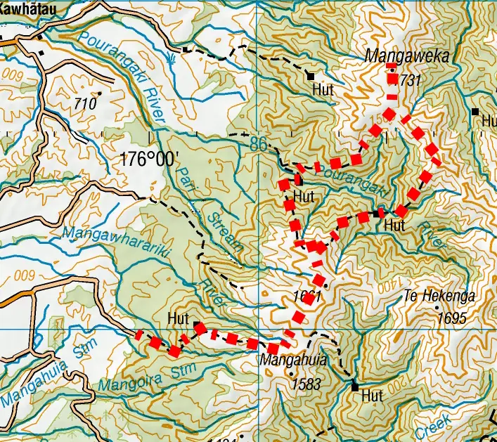
Renfrew Road to Kelly Knight Hut via Maungamahue
We started from Renfrew Road, making quick progress on the well-graded track up to Rangiwahia Hut. Just north of Mangahuia, we veered off the official DoC track and set our sights north toward Maungamahue.
Top Tip: On the way to Maungamahue, we ended up sidling at the 1,540m level. However, on our return journey, we stuck to the ridgeline. We found a good foot trail that was certainly much easier than sidling.

A cold snap had swept through the country a few days earlier. On the climb to point 1614, I found myself plugging steps through knee-deep snow for the group. It was exhausting work fighting uphill through the soft snow. Determination kept me moving while enjoying the views out west to Mt Taranaki.


Once we topped out, Tayla took over the lead down towards the lower Pourangaki peak. The descent to Kelly Knight Hut was steep, we lost the trail once or twice in the leatherwood at the top of the descent and lower down amongst tree fall from recent storms.
Our knees collectively sighed in relief when we finally arrived at Kelly Knight Hut. While our original ambitious plan was to push through to Purity Hut, it was now after 3:00pm so we made the sensible decision to call it a day. The hut had a quirky greeting waiting for us: a small skeleton figure dangling from the balcony and someone with a good sense of humour had also put a power outlet on the wall of the hut as a joke.


The Mystery of the Pegs and Mangaweka Summit
The next morning began with a chain across a narrow rock ledge to get us onto the swing bridge before we could begin the relentless, steep climb up to Wooden Peg. A thick blanket of clouds quickly set up residence around us, though Tayla remained optimistic that they were just doing a passing visit.
Top Tip: The track north of Kelly Knight Hut has been rerouted in two places along this section, and the topo map has not yet been updated to reflect this. The actual track is well marked though so this won’t cause any navigational issues, and we only noticed when we overlay our gpx file on the topo map.


Top Tip: Above the bushline on the way to Wooden Peg there are a number of tarns that are not marked on the map. There are good camping spots around them.
When we reached the top of Wooden Peg, the mystery deepened: right there, at the summit of Wooden Peg, was an iron peg. Naturally, this left me completely unsure of what to expect at Iron Peg itself. Unfortunately, we sidled slightly under the summit of Iron Peg, leaving its true hardware identity an unsolved mystery for another trip.

As we pushed higher toward the Mangaweka summit, the clouds began to slowly clear as Tayla predicted. They parted beautifully at the top, revealing spectacular, sweeping views:
- The frozen alpine tarns glittering below Mangaweka.
- The rugged, spiky silhouette of the main Ruahine Range.
- The Mokai Patea Range stretching into the distance.
- The stunning, snow-dusted southern aspect of Mt Ruapehu cutting through the horizon with Mt Ngauruhoe behind it.


A Runaway Phone and the Descent to Pourangaki Hut
Heading south-east from Iron Peg toward Point 1632, the ridge narrowed out due to erosion, making for some incredibly fun and focused travel. Blasted by an icy-cold wind, we couldn’t stop for long. Below us, the bright orange roof of Waterfall Hut teased us, but time constraints meant saving it for another day.
Top Tip: The ridge from Iron Peg to the Pourangaki Hut Junction was slow and could be challenging for those with a fear of heights/exposure. DoC time from Iron Peg to Pourangaki Hut is 3 hours but this is a fast time. Allow 3.5 – 4 hours.


Just above the Pinnacle Creek slip, disaster almost struck. Jamie’s phone made a dramatic dive for freedom from her pocket, sliding 50m down a steep, snowy slip. I carefully navigated down the slip and over the snow to retrieve her phone that now looked slightly worse for wear but surprisingly still worked.
At Point 1632, we reached the junction sign for Pourangaki Hut. From here, a brilliant foot trail followed the ridgeline before dropping into a steep, gravity-defying descent toward the Pourangaki River. I loved this section, even if our group suffered a few accidental slides on the slick terrain.

Arriving at the river, we were momentarily baffled to find the suspension bridge missing. We then realized we had to cross a small tributary of the river to reach it. As we crossed the beautiful small canyon we were now in, two whio (blue ducks) swam right past us.
We climbed up a short climb on the other side of the suspension bridge to find Pourangaki Hut looking fresh after recent renovations. Because it sits in a deep valley, it doesn’t get much winter sun, and everything felt quite damp. However, Anne, Jamie, and I finally coaxed the woodburner to life, eventually making the hut possibly a bit too toasty overnight which was quite an achievement.
Top Tip: There is a direct track down to the river from Pourangaki Hut, but be prepared—it is a steep 80m grunt back up!
Day 3: Heading Home via Rangiwahia
The final morning began with the climb back up to Point 1614. The track was well-marked, and I even spotted a beautiful, intact Powelliphanta snail shell nestled in the tussock. These carnivorous snails are the giants of the snail world but they are also one of New Zealand’s most threatened invertebrates.

Thankfully, the snow from two days prior had mostly melted away under the sun. This made for an easy, scenic cruise back along the ridge towards Rangiwahia Hut and the carpark, concluding another fantastic Ruahine tramp
It was a trip I really enjoyed due to it being quieter and more rugged terrain. I’ll be back to explore the Hikurangi Rage north of Mangaweka peak and solve Iron Peg’s mysterious hardware identity.
Top Tips: Topo Maps BL36 Norsewood & BK 36 Taoroa Junction
Day 1 Renfrew Road to Kelly Knight Hut via Rangiwahia Hut:
7-8 hrs | 1,155m elevation | 16km
Day 2 Kelly Knight Hut to Pourangaki Hut via Wooden Peg, Mangaweka, Iron Peg
9-10hrs | 1,793m elevation | 14.3km
Day 3 Pourangaki Hut to Renfrew Road via Rangiwahia Hut
7hrs | 1,235m elevation | 14.8km
Trip completed April 2026