Cameron Valley to Ashburton Glacier: A Trans- Alpine Tramping Trip.

Upper Ashburton Glacier

Traversing the Ashburton Glacier in Hakatere Conservation Park stands out as one of my more memorable and exhilarating tramps in New Zealand. Interestingly, this trip started as a backup plan. We were waiting for the Clyde River levels to drop so we could attempt to tramp into the legendary Garden of Eden ice plateau. Instead, the Arrowsmith Range delivered an unforgettable alpine adventure.

Hakatere Conservation Park is a fantastic area to explore. It’s packed full of easier and more challenging tramps. For example: Mt Somers & Mt Potts.
We didn’t end up making it to the Garden of Eden ice plateau that year as the Frances River was still too high for us to safely cross. Instead we found an alternative glacier in Aoraki/Mt Cook National Park exploring the Annette Plateau and Metelille Glacier.
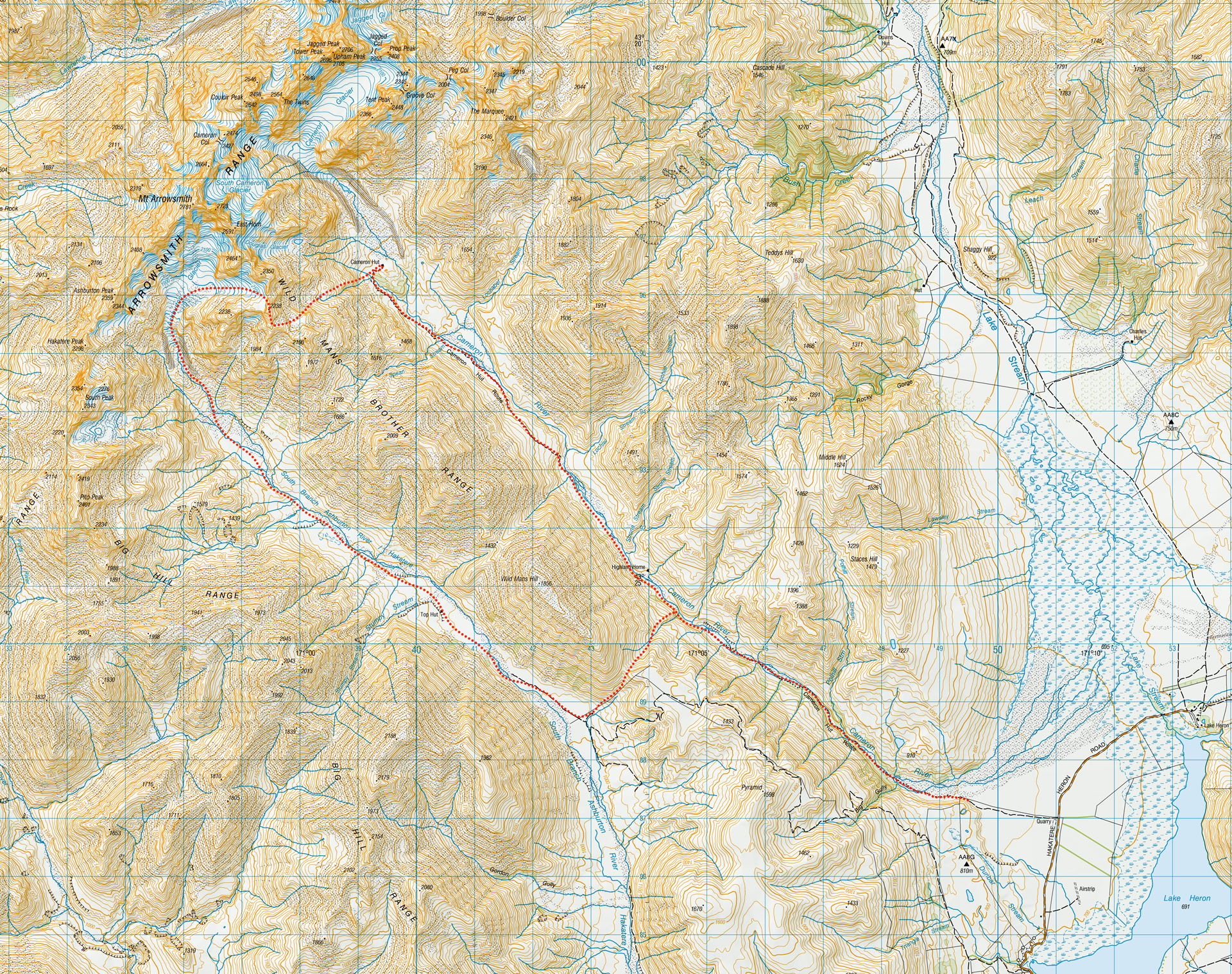
Topographical map of route taken around Cameron Hut - Ashburton Glacier - Top Hut Circuit, Hakatere Conservation Park, Canterbury

Roped mountaineers navigating a vast, sun-drenched slope on the Ashburton Glacier during a challenging alpine crossing, Hakatere Conservation Park, Canterbury
Traversing the Ashburton Glacier. Photo: Mathew Denys

Day 1: Snow Flurries, Spiky Flora, & Iconic Purple Door of Cameron Hut

6hr | 729m elevation | 15.8km

Starting from Hakatere Heron Road, we headed up the Cameron Hut Route, following the Cameron River valley on the true right. The trail alternated between riverside sections and terraced flats, with plenty of prickly matagouri bushes to keep us company.

Top Tip: Before you set off, make sure to sign the intentions book at the start of the Cameron Hut route. It crosses private land, and the owners like to monitor access. 

A group of four trampers with large multi-day packs gathered around a metal box containing the intentions book at the start of the Cameron Hut Route, Hakatere Conservation Park, Canterbury
Signing in the Intentions Book at the start of the Cameron Hut Route
The fast-flowing, milky-blue waters of a swollen Cameron River under overcast skies, with a small historic musterers’ hut, Highland Hut, visible on the far river flats. Located in Hakatere Conservation Park, Canterbury
Flooded Cameron River with the historic Highland Home. The Cameron River looked very different 2 days later!

About halfway up, we spotted the historic Highland Home (a private musterers’ hut) on the true left. The Cameron River was running high after recent rain so it wasn’t safe to cross on our way in, though we managed to visit it on the return leg.

The braided Cameron River flowing through a vast, deep alpine valley with golden tussock and scree-covered mountains under a striking blue and white sky. Located on the Cameron hut Route, Hakatere Conservation Park, Canterbury
Cameron River Valley

Snow Flurries & Iconic Purple Door of Cameron Hut

After about 10km, there was a cairn to indicate that the track climbed 160m onto a high river terrace. While bypassing a gorged section of the river it simply traded water hazards for the classic Canterbury joy of battling through a dense village of healthy spaniards and matagouri bushes.

Just past Spean Stream, summer threw us a curveball: it suddenly started snowing. Watching snow flurries float down in the middle of summer just after Christmas felt incredibly magical. The final kilometer to the hut was slow as the track meandered over large boulders and we were all feeling the weight of packs heavy with alpine gear.

A high-angle view from a steep river terrace looking down a steep valley where the swollen blue Cameron River carves through massive scree mountain slopes. Located on the Cameron Hut Route in Hakatere Conservation Park, Canterbury
Climbing above a gorge in the Cameron River
A single tramper with a large backpack navigates a rocky, boulder-filled track in the upper Cameron Valley on the route to Cameron Hut, Hakatere Conservation Park, Canterbury
Blue skies & snow flurries didn’t seem compatible.

Cameron Hut is a Canterbury Mountaineering Club Hut. It is best known for its iconic bright purple door and its prime location nestled deep within the dramatic glacial basin amongst piles of moraine from the Cameron Glacier. The hut feels like a tiny little doll’s house under the towering and jagged peaks of the Arrowsmith Range. It’s an amazing place especially given it’s only 6 hours walk in. 

The small green Cameron Hut nestled in a massive, rocky glacial basin of the Cameron Glacier beneath the steep scree slopes of the Arrowsmith Range, including The Marquee, Hakatere Conservation Park, Canterbury
The impressive glacial basin with Cameron Hut
Four trampers with backpacks standing outside the green, purple-doored Cameron Hut at the head of the Cameron Valley, nestled below the towering scree slopes and rugged peaks of the Arrowsmith Range, Hakatere Conservation Park, Canterbury
That iconic purple door!

The Cameron Glacier, Hide-and-Seek & the Circus of Kea

After dropping our gear, we headed further up the valley to get a better vantage point of the Cameron Glacier, guided by a few helpful rock cairns. Even though the Cameron Glacier has clearly receded a long way, it’s still amazing to see.

Once back at the hut a challenging game of hide-and-seek ensued. Emily managed to find the ultimate hiding place in the hutch in the centre of the hut with the help of Ilona and Tony. Matthew and I spent a long time turning the hut upside down looking for her with absolutely no success. Suddenly she leapt out of the hutch giving us a massive surprise. To add to the entertainment, a circus of very vocal kea circled around outside the hut.

The receding Cameron Glacier with its moraine wall at the head at the Cameron Valley above Cameron Hut, Hakatere Conservation Park, Canterbury
The receding Cameron Glacier
Two hikers descending from Cameron Glacier a rocky, tussock-covered ridge route back into the wide glacial basin of Cameron Hut in the Arrowsmith Range in Hakatere Conservation Park, Canterbury.
Heading back to Cameron Hut. Emily easy to see in her orange jacket but she wasn’t easy to see in the hut when she hid!
Looking across the wide, rocky alpine flats at the head of the Cameron Valley toward the steep rock walls and permanent snowfields of the Arrowsmith Range, Hakatere Conservation park, Canterbury
The impressive Arrowsmith Range: head of the Cameron Valley with Cameron Glacier visible

Day 2: Traversing the Ashburton Glacier Traverse and Pulverised Crackers

10 – 11 hr | 1,095m elevation | 13.5km

The next morning began with a long, sustained climb through tussock and scree. Once we gained the ridge heading north towards point 2,238 there were a few narrow, technical sections that had a decent amount of exposure and required total concentration. 

A group of trampers sitting with their backpacks on a tussock and scree slope, taking a rest break while looking up at a massive scree basin above Cameron Hut in the Arrowsmith Range while on a trans-alpine tramp to Ashburton Glacier, Hakatere Conservation Park, Canterbury.
A well-deserved break during the long climb up to the ridgeline above Cameron Hut

As we started to stop for a well-deserved lunch stop after point 2,238, a rogue boulder came tumbling and landed square on the lunch I had just pulled out from my pack. My crackers were now thoroughly living up to their name—they were completely pulverised!

The Ashburton Glacier

We finally got to the exciting and ultimate goal of the trip: the Ashburton Glacier. The initial descent was a straightforward snow slope that we could safely slide down with a good, long run-out.

Once the terrain levelled out, we stopped to gear up, putting on our crampons and harnesses and roping up for the glacier traverse. There were obvious crevasses here because of the convex rolled out nature of the terrain. 

Walking across the ice was nothing short of incredible, especially since we got lucky enough to have such perfect weather for it. Mt Arrowsmith towered grandly above us, and the deep blue hue glowing from the depths of the crevasses was breathtaking. We took our time exploring, carefully navigating the ice. We had to jump across a few bigger crevasses that were too wide to simply step across while remembering to be cautious about the lip of the crevasse. Our team had done multiple glacier practice sessions so our communication and teamwork were flawless in ensuring the length of the rope in front and behind us was adequate and everyone felt supported.

Top Tip: It is possible to avoid the glacier traverse by keeping to its margins with care

A team of three mountaineers in helmets and backpacks attaching a climbing rope together on the ice of the Ashburton Glacier, preparing for a crevasse crossing. Located in Hakatere Conservation Park, Canterbury
Getting prepared for glacier travel
Two mountaineers roped up for safety while descending a steep snowfield on the Ashburton Glacier, equipped with helmets, ice axes, and climbing harnesses against a vivid blue sky in the Arrowsmith Range, Hakatere Conservation Park, Canterbury
Tony & Emily on the Ashburton Glacier
A line of four mountaineers roped together for safety as they descend a vast, open snow slope on the Ashburton Glacier under a deep blue alpine sky, Arrowsmith Range,  Hakatere Conservation Park, Canterbury
Heading down the Ashburton Glacier. Photo: Mathew Denys
A female mountaineer with a large backpack and helmet carefully holding a rope while stepping over a deep, open crevasse on the Ashburton Glacier, Arrowsmith Range, Hakatere Conservation Park, Canterbury
Sarah preparing to jump over a crevasse. Photo: Mathew Denys
Two hikers on a harness and rope on the Ashburton Glacier in the Arrowsmith Range, Hakatere Conservation Park, Canterbury
Ilona & Mathew on the Ashburton Glacier
The upper snowfields of the Ashburton Glacier showcasing cracked ice formations and active crevasses beneath towering, dark rock ridges of the Arrowsmith Range, Hakatere Conservation Park, Canterbury
Visible slots on the Ashburton Glacier
A close-up shot of a deep, dramatic slot crevasse opening up in the white ice of the Ashburton Glacier, Arrowsmith Range, Hakatere Conservation Park, Canterbury
Another deep slot

The Endless Moraine Wall

After the high-energy excitement of the glacier, we were quickly brought back down to reality with the long descent over the moraine wall. It was a long slog over the moraine. Emily and Matthew, who are boulder hopping experts, quickly left us in their dust. Ilona, Tony and I wished we had their speed and skill as we slogged over the endless moraine.  

A massive, challenging moraine wall consisting of loose grey rocks and scree, which trampers must descend after traversing the Ashburton Glacier. Arrowsmith Range toering above. Located in Hakatere Conservation Park, Canterbury
The endless moraine
Trampers carefully route-finding down a steep, highly technical moraine wall of loose grey boulders and unstable rocks leading off the Ashburton Glacier, In the Arrowsmith Range, Hakatere Conservation Park, Canterbury
And yet more moraine

We were all incredibly glad to finally drop into the South Branch of the Ashburton River, even if we were immediately greeted by our old friends: spaniards and matagouri.

By this point, exhaustion was setting in. It had been a massive alpine day, and dusk was settling by the time we finally stumbled into Top Hut where a group of hunters had been tracking our progress down the river. Dinner turned into much laughter as Matthew’s dehydrated meal had feta in it and the rehydrated feta squeaked loudly as it was eaten.

Hikers walking towards Top Hut on a 4wd track amongst tussock next to the South Branch Ashburton River at dusk, Hakatere Conservation Park, Canterbury
Very glad to finally reach Top Hut at dusk

Day 3: Wild Mans Brother Range

4 – 5hr | 316m elevation | 14.6km

After packing up our tents the next morning we were all keen to get moving to get into the sun to warm up. We quickly found a 4wd track next to the river. The river was easy to ford and we continued following this road to the private Wild Mans Hut and the fenceline that marked the boundaries of conservation land. The fenceline provided the perfect place for us to climb up onto the Wild Mans Brother Range, before dropping into a stream to follow back down into the Cameron Valley. 

A hiker sorting gear outside the rustic, corrugated-iron Top Hut in the Hakatere Conservation Park on a clear, sunny morning, Canterbury
Sometimes the best place to dry gear is on the roof of the hut!
A lone corrugated-iron longdrop toilet standing in a vast, golden tussock valley with the dramatic scree slopes and snow-capped peaks of the Arrowsmith Range in Hakatere Conservation Park, Canterbury
Not many toilets have such a fantastic view
Four hikers with backpacks hiking along the rocky, gravelly banks of the fast-flowing South Branch Ashburton River/Hakatere beneath a towering scree mountain slope. Near Top Hut, Hakatere Conservation Park, Canterbury
Looking up the South Branch Ashburton River/Hakatere towards the Arrowsmith Range

Looking back, what started as a backup plan turned into one of the most rewarding trans-alpine loops I’ve ever completed. The Arrowsmith Range doesn’t give away its views easily—you have to pay your dues in matagouri scratches, crushed crackers, and hours on loose moraine—but the reward of walking beneath Mt Arrowsmith and navigating the crevasses of the Ashburton Glacier made every step worth it.

Front view of the rustic, corrugated-iron musterers' hut called Wild Mans Hut under a bright blue sky, featuring an open wooden door and a gas barbecue sitting out front in a grassy basin. Located near Top Hut in the South Branch Ashburton River, Hakatere Conservation Park, Canterbury
The private Wild Mans Hut
A sunny afternoon view looking down the golden tussock slopes of the Cameron Valley, with a winding river below and the jagged, snow-capped Arrowsmith Range in the distance. Historic Musterers' Hut, Highland Hut, is visible on the far bank of the Cameron River. Located in Hakatere Conservation Park, Canterbury
Descending off the Wild Mans Brother Range into the Cameron Valley again

Leave a Reply

Your email address will not be published. Required fields are marked *