The jagged silhouette of the Remarkables Range is the first thing most people see when visiting Queenstown. For years, the Wye Creek route was just a line on a topo map for me. A logistical puzzle of an alpine one-way route that seemed perpetually out of reach. But when we had a spare day in Queenstown, we took the opportunity to complete the Wye Creek Route. A traverse of the Remarkables Range that drops from dramatic glacial cirques into basins full of golden tussock.…

The iconic Remarkable Road
The Wye Creek route is a track I’ve eyed on the map for years. However, because it traverses the Remarkables Range and finishes at a different location from the start, the logistics can be complicated. After a trip to Earnslaw Burn Valley, Emily, Mathew and I found ourselves with a spare day and good weather. The journey begun with a drive up the iconic Remarkables ski field road which is a bit of an adventure in itself.
Top Tip: There is a $15 road toll, and you should always check conditions before heading up. Even in summer, snow is possible. The road is mostly sealed, but the final 3km are gravel with steep drops and windy turns. The route starts and finishes in a different location so either you need two cars or someone to pick you up.
Top Tip: There is a toilet at the Ski field and just before the Wye Creek Bridge carpark at the end of the route.

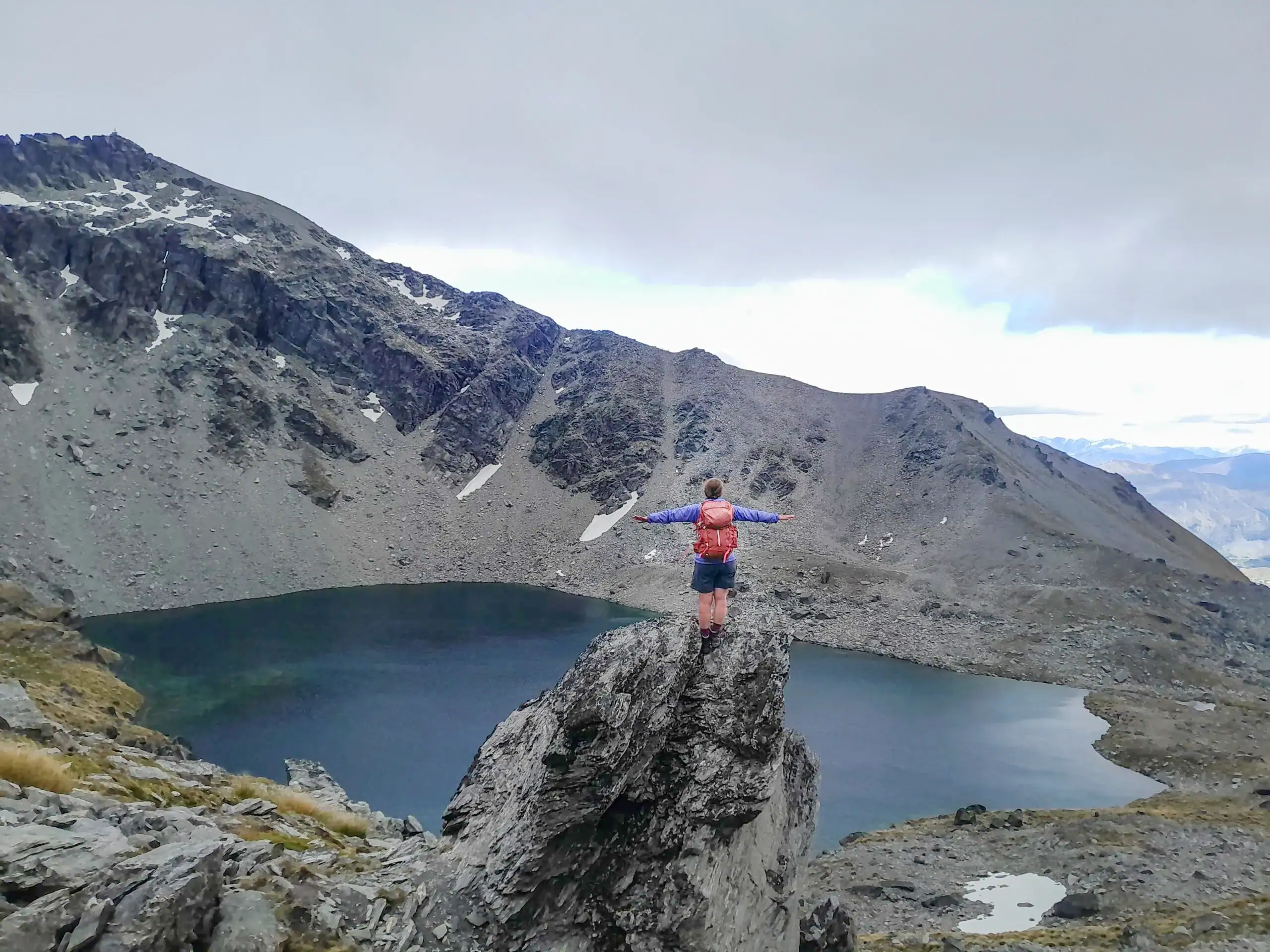
Lake Alta
We began at the top of the road (1,600m) and followed the ski field road to the top of the Alta Chairlift, eventually reaching Lake Alta. This stunning glacial lake sits in a natural “cirque”—a massive amphitheatre at the head of the valley—beneath the towering Double Cone Peaks.
Top Tip: The higher altitude of this tramp means it is often very cold and can have snow, even in summer. There is no marked track beyond Lake Alta.


Navigating the Wye Creek Basin
After climbing to the saddle and enjoying a few sneaky snowball fights, we began our descent. The route takes you past pristine glacial tarns and through golden tussocks. Not to mention different species of spaniards – my favourite was the Congested Speargrass (Aciphylla congesta). This species reminded me of the mega herbs I had seen in the Sub-Antarctic Islands. It was great to see conservation in action with kea-proof DOC200 and A24 traps to protect the fragile ecosystem from stoats, rats and hedgehogs that are encroaching on the area.


Emily took off to do her own solo peak bagging mission. This worked out perfectly as she would drive the car around to the Wye Creek bridge carpark to meet us. Mathew and I found the route descended steeply on the true left next to a spectacular waterfall dropping dramatically to the floor of the upper basin. The couple we met here warned us that the route became more difficult to navigate and they had battled the prickly spaniards. I think the spaniards must have had it out for them because we didn’t have the same difficulties luckily. We did find that the foot trail was sometimes difficult to follow and the tussock and spaniards were clearly having a great year, so it was a bit slow at times because we couldn’t see where our feet were going!
Top Tip: If you lose the foot trail or cairns, look for the next pest trap—they often serve as helpful markers.


Lower Wye Creek and the Hydro Dam
As we entered the Lower Wye Creek Basin, the terrain transitioned into lush beech forest. The track becomes significantly easier here.
Near the hydro dam, we followed a series of platforms along the base of impressive rock bluffs. This area is a popular hub for rock climbers and is an area where Mathew has been climbing a number of times. From the dam, the track followed the pipeline in a series of zig-zags, dropping us down to the Wye Creek Bridge carpark on the State Highway. Emily turned up just as we arrived and had even given the two people we met a ride down the Remarkables Road.

The Wye Creek Route is a rewarding and diverse traverse that offers everything from alpine scree to native forest that is very close proximity to Queenstown and making it perfect to fill in a spare day between adventures.
Top Tip: Topo Map CC11 Queenstown
Wye Creek Route – 5-7 hrs, 512m elevation, 17km
