Nothing is ever simple in the Seaward Kaikōura Range in Ka Whata Tu o Rakihouia Conservation Park. Tony and I have a running record with this rugged terrain where trips rarely go to plan. From the “Shattered Peak” mission to our trip into Jam Hut, this range always keeps us on our toes. Our recent attempt at Mt Tarahaka was no different—featuring vigorous tōtara trees and a road to nowhere.

The Boulders of George Stream Again
We began the tramp at George Stream, greeted immediately by my nemesis: the boulders. After our Jam Hut mission, I wasn’t thrilled to see them so soon. Fortunately, we only had to endure a kilometre of boulder hopping (though it felt like the longest kilometre in the world) before turning off onto a forestry road through a pine plantation.
Top Tip: The Waiau-Toa ford over Wharekiri Stream must be crossed to get to George Stream. This is 4WD only and is prone to flooding. It can be impassable for up to 2 weeks. The 2016 Kaikōura earthquake destroyed the former Glen Alton Bridge. The is currently no funding to replace it.

Navigating Ambiguous Routes and Bush Bashes
After climbing steep switchbacks, we reached a hunters’ lodge complete with some curious horses. Following a vague route description from a previous tramper, we took a west turn across a stream. It looked like the road leading up this hill suddenly stopped and went nowhere.
Lesson Learned: Always walk just five minutes further. I suspect the road outline was just over the next rise, but instead, we retraced our steps and took the left fork.

We thought we had struck gold with this road but we soon found it led us toward spotheight 520, well south of our intended route. We were committed on our route and clearly don’t like doing things the easy way either (like our tramp over George saddle a few weeks earlier). What followed was an “adventurous” bush bash. Having survived the Matiri Range bush bash, we were now very adept at suffering. The bush soon became very dense, and my ice-axe kept getting ensnared in tree branches—a total repeat of the Shattered Peak climb.
Fortunately we had done a large amount of climbing on the 4-wheel drive road so the bush bash sufferfest wasn’t too prolonged and we soon emerged into open tussock only to be greeted by a ‘friendly’ village of matagouri.

Camping with a view
The struggle was rewarded when we reached spotheight 1191 on George Spur that was our campsite for the night. After fetching water from a trickle 10 minutes south of camp, we settled in. We listened to the calls of a cheeky kea and enjoyed watching the sun setting over Mitre, Alarm and Tapuae-o-Uenuku peaks. This was followed by a truly spectacular Milky Way. We could even see the glow of the lights from both Wellington and Kaikōura.


The Mystery of the “Dino-Chickens” of Mt Tarahaka
The next morning brought a bizarre sound: something that sounded exactly like chickens but surely that was not possible where we were camped on the ridgeline. Back in Wellington, our friend Anne dubbed them “dino-chickens.” Given that Tony and I have a habit of finding “dinosaurs” in odd places, it felt like a fitting explanation for the mystery.


Mt Tarahaka’s Knife-Edge Ridge
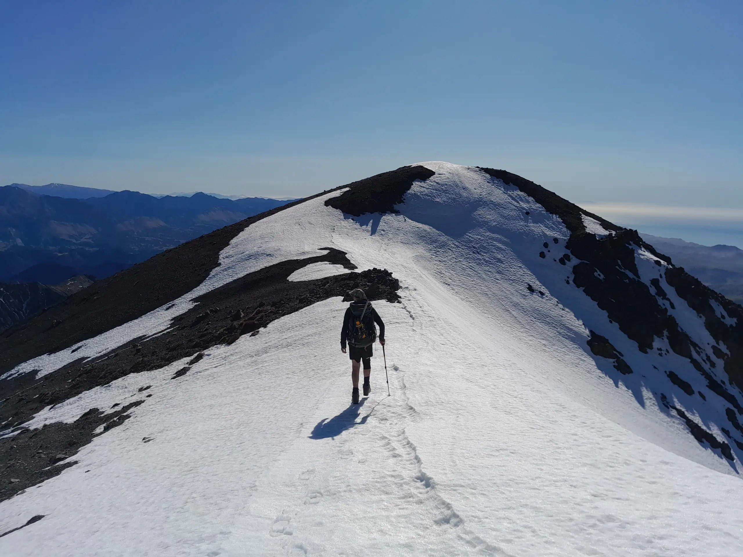
We climbed up George Spur toward point 1722 in the stunning early morning light as the sun rose. I love this time of morning. Not only is the light beautiful but it is a reminder of the endless possibilities for the day to come. However, at the 1,800m contour line George Spur soon turned into a narrow knife-edge with steep, nasty drop-offs on either side from erosion and there was no nice scree but rather stones that felt like ball bearings under our feet.
The Kaikōura Range is predominantly greywacke rock and this makes it very prone to erosion. It feels a bit like a biscuit crumbling. Unlike Tony’s previous trip here where it was an easy walk on crampons across snow, the bare rock felt too high-risk. It had been a warm winter and there was no snow on the ridge. We made the easy decision to stop and turn around for safety. As I talked about in another trip report, the ultimate goal of every trip is never about the summit or the distance but rather coming home safe.

Stalked by Horses and Vigorous Tōtara
Our descent from our campsite at point 1722 was a classic Seaward Kaikōura puzzle. It started with following along the old farming fence that our route information indicated, climbing over and under the fences. We were looking for an old farming road that had been mentioned in the trip report. Deciding this road must be a ghost road, we changed plans and picked a spur to follow down.
After we had been descending for a while, I finally spotted a road. The only problem was that we had to bash through vigorous tōtara trees to get there. We were crawling and sliding under the low branches. Popping out onto this road, we realised our next problem. This road wasn’t marked on the map, and we had no idea where it went! Finding horse droppings was a relief because if our horse friends from the hunting lodge could get up there, we surely could follow it back down to them. Soon the gallop of hooves startled me and l looked up to see the horses running straight at us. Fortunately, they were simply curious about us, wanting to nibble on Tony’s shirt and steal his snacks, before following us through the pine forest.

A Shocking Conclusion
The trip ended with one last surprise. While holding up a fence for Tony back at George Stream, I received an electric shock. It felt like another sharp reminder that the mountains always have the last word.
While we didn’t reach the summit of Mt Tarahaka this time, we still had a fantastic time camping up on the ridge and adventure to find the road. It was a mission well worth the effort. We’ll be back again.
In the meantime, we were now heading down to Mt Princess to see the Princess Bath in the winter.

Trip completed September 2023
George Stream to pt 1191 on George Spur: 5 – 6hr | 9.72km | 1,259m elevation
George Spur Campsite to 1800m contour line on George Spur & return with descent via point 1040: 8 – 9 hr | 14.3km | 813m elevation