Mt Gladwish (1,861m) is a peak with a uniquely cheerful name nestled in the rugged Ahuriri Valley. While it hasn’t been climbed particularly often in the past, its inclusion in the newly published New Zealand Alpine Club (NZAC) book The High Pathways by Paul and Shelley Hersey is rightly putting it on the radar for alpine trampers and mountaineers.
Tony had been purely drawn in by its playful name, even before the book was published. In May, we finally decided to head back into the Ahuriri Conservation Park to climb it. I had only been in the Ahuriri Conservation area once when I had done a trip over Maitland Pass into the Ahuriri Valley with our friend Matt.
Camping at the Ahuriri Conservation Park Boundary
After spending a few days based at Unwin Lodge—a few day trips up Mt Sebastopol and Mt Wakefield—we drove into the depths of the Ahuriri Valley.
We set up camp just past the Birchwood Homestead cattle stop, right next to the boundary fence to gain the shelter of the trees. Due to the high fire risk in the long, dry grass, we had to resort to cooking dinner right in the middle of the gravel road!
Top Tip: There are other camping spots amongst the matagouri further up obvious 4WD track that runs parallel to the boundary fence to the base of the hills

It was a bitterly cold night. We woke up in the early hours to find the insides of our tents completely frozen, resulting in a miniature shower of ice when we unzipped the fly in the morning. I found my trail shoes had frozen in the car overnight and were so stiff that I immediately ditched them and put on my tramping boots instead. Luckily, our route started with an immediate, steep climb to defrost us.
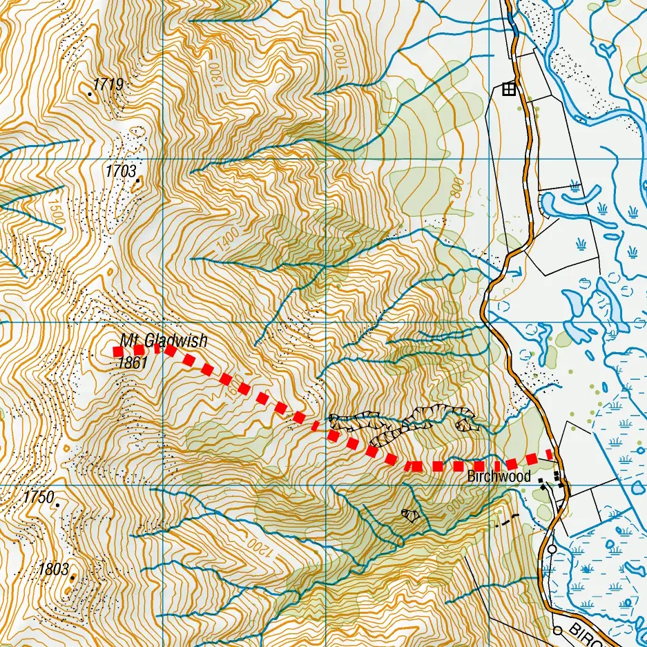
Mt Gladwish Route Guide & Navigation
The route up Mt Gladwish is very straightforward:
- The Start: Look for the four-wheel-drive track next to the boundary fence by the cattle stop immediately after the Birchwood Homestead.
- The Ascent: A faint foot trail leads directly up the hill. While I spotted one random piece of pink flagging tape, navigation is very easy as the subalpine scrub is very light and the route simply climbs up to the ridge.
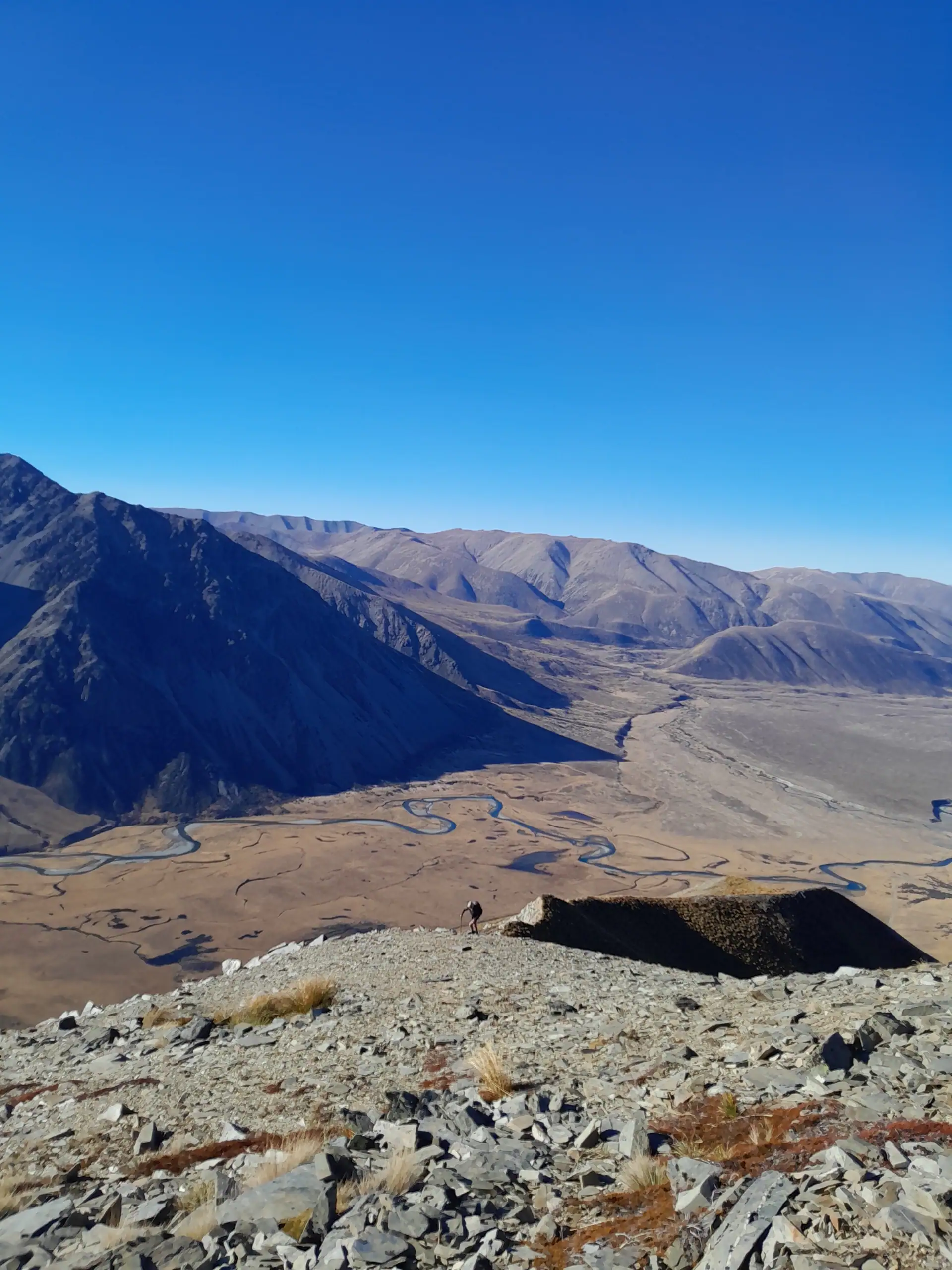
- The Ridge: After passing the top of two very prominent slips, the ridgeline becomes slightly more technical with loose boulders in one or two places. We sidled on both sides but found the western side to be noticeably easier. There is nothing exposed on the ridge or any difficult terrain though and it is all very much achievable.
Being May, we encountered patches of frozen scree on the upper faces, but nothing that hindered our progress to the top.


The Summit Views
At 1,861 metres, the summit of Mt Gladwish delivers an incredible reward for a relatively short climb. The panoramic views looked straight down the Dingle Burn Valley, across to the impressive peaks of Mt Barth, Mt Helm, and Mt Huxley, and further afield to the distinctive peak of Mt Aspiring / Tititea shimmering on the horizon.
If you are looking for an alpine trip that combines excellent accessibility with total solitude, Mt Gladwish is ideal. You are unlikely to encounter many other people—or anyone at all—on this route.


Future Plans: The Dingle Valley Loop
Standing on the summit got the planning wheels turning once again. I’m already thinking about returning in the summer to turn this into a multi-day loop. The plan would be to drop through into the Dingle Valley, follow the river up to the Ahuriri Valley, and then traverse the long ridge south of Mt Gladwish all the way back out towards Lindis Pass. Watch this space!
Top Tips: Topo Map BZ14 Mt Barth
Navigation skills are required. There is no marked track.
Time: 5-7 hrs | Elevation: 1,172m | Distance: 6.5km
The drive to the base of Mt Gladwish is a gravel road and has a couple of tight corners. After the Ben Avon Lakes the road gets rougher – this rough section is about 4km. It is still drivable by a 2WD vehicle with low clearance, but travel will be slower. Allow plenty of travel time.
Trip completed May 2026