If you are looking for an incredible winter backcountry mission near Christchurch, tramping Mt Potts in the Hakatere Conservation Park should be right at the top of your list. When an airline luggage mishap leaves you stranded at the airport without your alpine gear, this stunning 4-day loop via Mystery Lake, Potts Hut, and Boundary Creek Hut offers the perfect, high-reward alternative. From navigating frozen high-country tarns to zooming down epic Canterbury scree slopes, here is everything you need to know to plan your own adventure to Mt Potts.

“The good news is that we have found your luggage. The bad news is that it’s still in Wellington.”
Uh oh. I was standing at Christchurch Airport after a 6:30 am flight, trying to figure out where my gear had gone. With no alpine gear and the next flight not until midday, my plans of being an “alpine dinosaur” were thwarted. (I have a fairly overactive imagination and think crampons look like dinosaur feet, so I’m always a dinosaur when wearing them!).
I stood there for a moment weighing my options:
- Wait around for the midday flight.
- Hire alpine gear from Further Faster in Christchurch.
- Re-plan the entire trip.
To make the best use of our limited time, my tramping partner Matt and I chose option three. He grabbed a spare walking pole, picked up a “rebel dinosaur” without her feet. Our original plan to explore the Huxley Valley and climb onto the spine of the Southern Alps would have to wait.
Instead, we decided to head somewhere closer to Christchurch that hopefully didn’t require alpine gear. Matt suggested a loop in Hakatere Conservation Park to climb Mt Potts. He’d done the trip the previous year with Tony but fortunately didn’t mind another trip to the area.
Day 1: Lake Clearwater to Potts Hut via Mystery Lake
Our starting point was Lake Clearwater. Despite its rather unimaginative name, it is absolutely beautiful. As we started, I noticed the reflections of the surrounding mountains looked a bit odd and then I realised that the lake was partially frozen! It was rather odd watching a bird sitting on top of the water rather than in it.

Climbing the Dogs Range
The ground was frozen solid underneath us with a slippery layer of mud on top. On the Eastern Link Track, Matt found a well-trodden shortcut straight “up the guts” rather than taking the switchbacks. It got our heart rates up instantly—no warm-up allowed!
We headed toward Mystery Lake. Like all the tarns we passed, it was frozen solid. We tossed a rock onto the surface, watching it skate across the ice while making a strange, echoing acoustic noise. Mystery Lake area lives up to its name with a bit of mystery from the surprise of finding a large Hall’s tōtara in what is otherwise a completely treeless area and the steep roche moutonnées (rocky ‘knobs’ smoothed by passing glaciers).
Coming off the Mystery Lake Track, Matt easily leapt across a deep creek. I, on the other hand, misjudged it and fell straight into the frigid water. Fortunately, we had a steep climb ahead to warm me back up.


Up on the Dogs Range on the Mt Potts track, Matt pointed out the Two Thumbs Range and Mt Somers. We now had soft snow to plough through. I spent the afternoon meticulously following deer hoofprints to help me gauge how deep I would sink in the snow with each step. I’m sure Matt was following behind wondering why I couldn’t just walk in a straight line, but those Hakatere animals clearly wouldn’t pass a sobriety test.

Arriving at Potts Hut
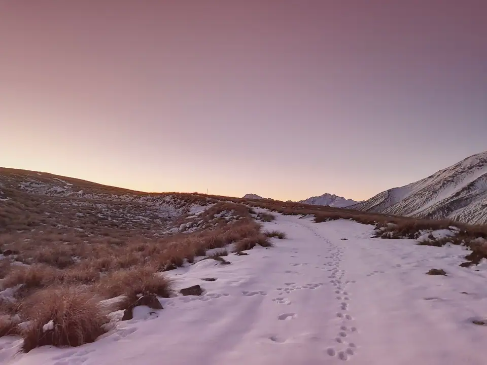
As the sun set, a spectacular alpine glow lit up the Potts and Big Hill Range and the Two Thumbs Range to our west. Walking down the zig-zag track to Potts Hut, we used our headlamps to navigate around slick patches of ice.
At one point, we thought another tramper was walking up the hill toward us in the dark. It turned out to be the highly reflective tape on the Department of Conservation (DOC) track markers. They made night navigation incredibly easy. Potts Hut is an old musterer’s hut built prior to 1899 and extended between 1947 and 1957.

Day 2: Mt Potts (2,060m)
The next morning, we set out with just day packs for an off-track mission. Our feet were instantly frozen during the Potts River crossing, but we quickly warmed up scrambling up the spur behind the hut toward Mt Potts.
As the alpine tussock gave way to loose scree, the real work began. I picked out a massive vegetable sheep (Raoulia eximia/tutāhuna) high up the ridge as a target, put my head down, and smashed out the climb. Despite the “snakes and ladders” nature of Canterbury scree, I was really enjoying the day especially since it was a lovely, bluebird day.

As we climbed higher, the snow deepened and we spotted a few tahr silhouetted against the skyline. We eventually reached 2,060m on Mount Potts, roughly 100 meters below the true summit. Here, the snow turned to hard ice. Without our crampons and ice axes it wasn’t safe to continue.
We made the safe choice to turn back. A tramp or alpine adventure does not require recklessness to become dangerous. The mountains do not care about your confidence, experience or fitness, but rather your preparation, timing, awareness and adaptability. These are the things that will keep you safe. The ultimate goal of every trip is never about the summit or the distance but rather coming home safe. Mt Potts will always be there another time to climb and next time I will have my dinosaur feet.

The Ultimate Scree Slide
After soaking in the immense views, it was time for the best part: the scree slide. I let Matt start, picked another line safely away from him, and absolutely sent it zooming down the mountain.
Back at Potts River, we gathered some firewood, only to return to Potts Hut and realize there was no wood saw. We did the best we could, breaking smaller branches with our hands and feet to get a modest fire going for the evening.


Day 3: Potts Hut to Boundary Creek Hut via the “Bobsled”
We woke up to find our boots and socks frozen solid inside the hut. After boiling up water to defrost our footwear, we took a more direct, off-track route back up to the Dogs Range.
At lunch, I built a mini snowman, fittingly naming him Mr. Potts. Looking out over the landscape, I wondered aloud to Matt if Canterbury weather was always this perfect and if I should move to Christchurch…….


Navigating the “Bobsled”
Heading down toward the Boundary Creek Hut junction, we encountered a massive expanse of thick ice covering a 100-meter section of the track. Matt aptly dubbed it the “Bobsled” because one wrong step meant total carnage, sending you sliding to the bottom of the hill with a no-return policy. Luckily, we easily bypassed it by walking off-track through the tussock. This time, I managed to jump the creek without falling in!
After one final climb, we began the long descent to Boundary Creek Hut, doing a few more ice avoidance diversions in the shady spots. We arrived just before 4:00 pm and immediately layered up as the winter temperature plummeted. Boundary Creek hut was built between 1902 and 1906. It once marked the boundary between the winter and summer grazing blocks on the old Hakatere Station.

South Island Giant Spaniards
Inside the hut, we flipped through the intentions book and laughed when we came across entries from Joe and his dog, Floyd, whom Tony and I have followed across many backcountry hut books.
I headed outside to capture the evening light, taking a photo of a friendly giant spaniard (Aciphylla colensoi). I had recently been trying to explain to my manager about these fiercely spikey native NZ plants that strangely enough belong to the carrot family. When I showed her the photo after this trip, she described it perfectly as “quite stunning in a terrifying sort of way.” While they are prickly horrors to bushbash through—and I’ve encountered vast villages of them taller than me—they are truly fascinating native plants.
I stayed out a bit longer to enjoy the brilliant stars before the cold drove me back to the safety of my sleeping bag.

Day 4: Boundary Creek Track to Lake Clearwater
By 8:00 am the next morning, we were on the move again after another round of pouring hot water over our frozen boots. We followed a rough 4WD track through vast tussock flats that looked entirely magical in the golden morning light. A few New Zealand falcons (kārearea) zoomed past as we debated the classic tramper’s argument: the merits of open tussock country versus deep beech forest.
At the Mystery Lake track junction, we encountered our first signs of civilization in four days: two locals on a 4WD buggy doing vital conservation predator control work targeting possums.
The final walk back to the car at Lake Clearwater was easy and we reached the car before 1:00 pm. Matt dropped me off at Christchurch Airport just in time to catch an earlier Air New Zealand flight. Looking out the window, I caught the last rays of sun hitting the Kaikōura Ranges and a stunning sunset as we touched down in Wellington—where I was finally reunited with my alpine gear after its boring four-day airport vacation.

Tramping Mt Potts: Trip Planning Notes
If you are looking to replicate this winter tramping loop in the Hakatere Conservation Area, here is what you need to know:
- Starting/Ending Point: Lake Clearwater car park (approx. 2 hours drive from Christchurch).
- Parking: Plenty of carparking at Lake Clearwater and seems a safe carpark with Lake Clearwater village nearby
- Route Taken: Lake Clearwater -> Eastern Link Track -> Mystery Lake Track -> Potts Hut -> Off-track Mt Potts spur -> Dogs Range route -> Boundary Creek Hut -> Lake Clearwater 4WD track.
Potts Hut: 8hr | 1,153m elevation | 23.6km
Mt Potts (Only to 2,060m): 8.5hr | 1,255m elevation | 8.6km
Boundary Creek Hut: 6hr | 900m elevation | 15km
Lake Clearwater carpark: 4.5hr | 248m elevation | 16.7km - Huts: Potts Hut (10 bunks, woodburner) and Boundary Creek Hut (8 bunks, woodburner). Both are basic DOC huts operating on a first-come, first-served basis and do not require hut tickets/hut passes. Both these huts are very cold and not insulated so take plenty of fire starters and warm gear.
- Winter Navigation: The tracks are all marked by orange snow poles with reflective tape on them. However, the spur up to Mt Potts summit is not marked and requires navigation skills and avalanche assessment skills. Alpine gear may be required even on the lower tracks depending on the conditions. Track times may be slower due to snow and ice over winter. The weather can change very quickly and high winds are common.
- Camping: Camping is permitted only on the northern and eastern sides of Lake Camp, where there are existing public toilets. Lake Clearwater also has a camping ground at the southern end with an honesty box provided.