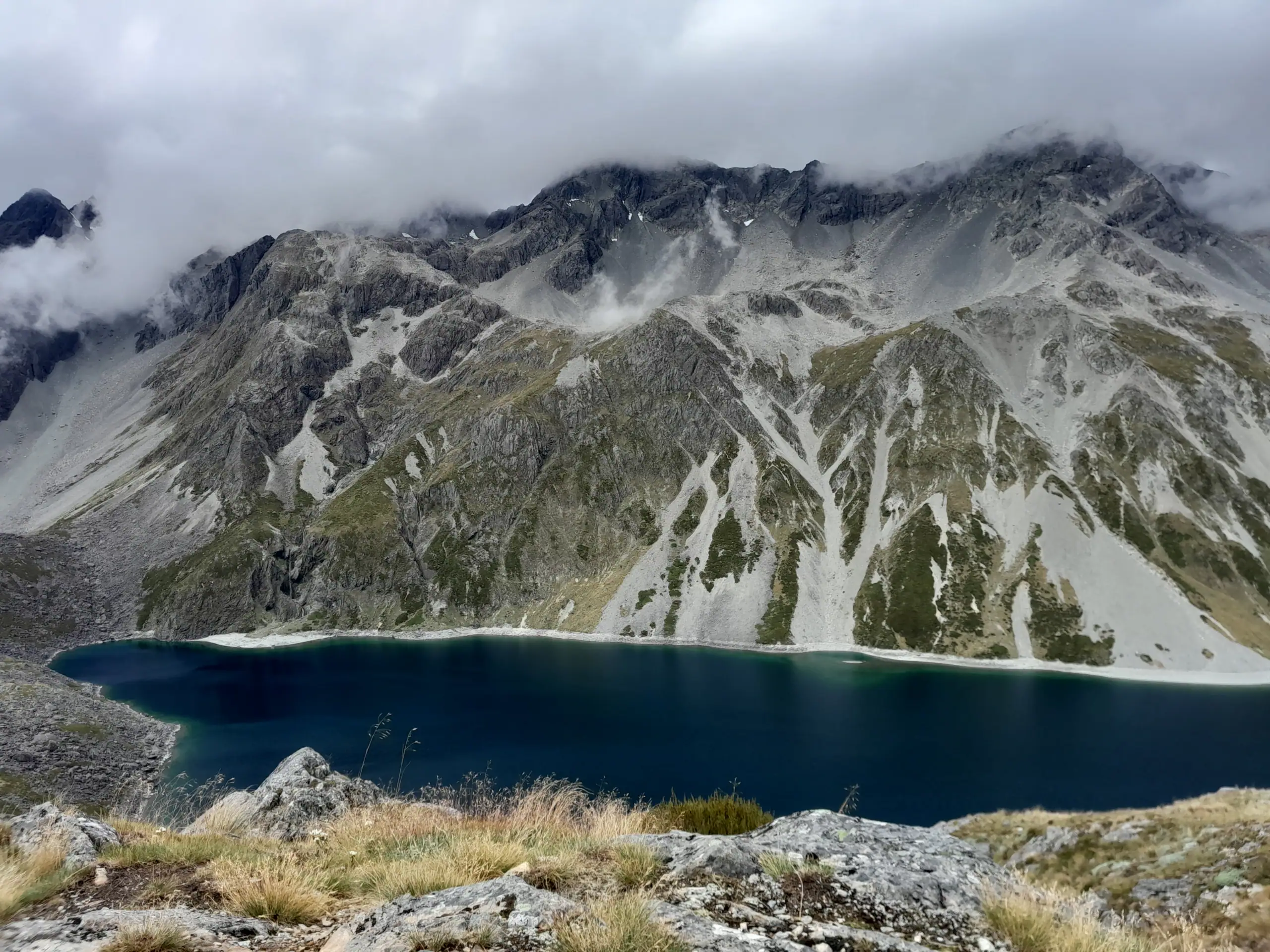
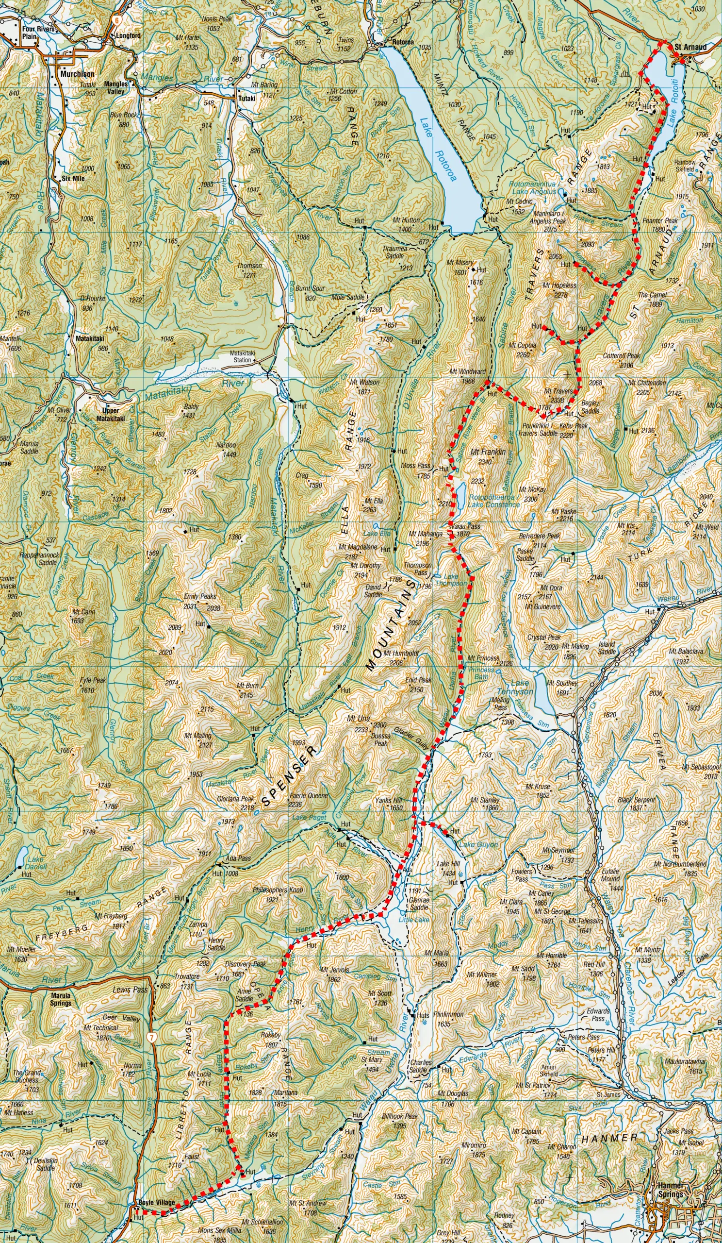
The Lewis Pass to St Arnaud route via Waiau Pass and Poukirikiri / Travers Saddle is one of New Zealand’s fantastic and challenging multi-day tramps. The 163 km journey crosses the St James Conservation Area and Nelson Lakes National Park, passing Lake Constance / Rotopōhueroa and Rotomairewhenua / Blue Lake before descending to St Arnaud.
This 7-day solo trip involved two technical alpine passes, long days, river crossings and rapidly changing weather. This guide covers the route, huts, transport, distances, hazards, best season and practical information you need to plan the trip.
Lewis Pass to St Arnaud Route Overview
- Location: Nelson Lakes National Park
- Topo50 Maps: BU 23 Boyle Village, BT 23 Lewis Pass, BT 24 Ada Flat, BR 24 Kawatiri, BS 24 Mt Robert, BR 24 Kawatiri
- Duration: 8-10 days, 163km, elevation 6,099m
- Difficulty: Expert / technical alpine route. High fitness, navigation, river-crossing and alpine skills required. The route is well marked by orange track markers and snow poles.
- Safety Video: From Mountain Safety Council: Waiau Pass; Travers-Sabine Circuit
- Direction: Can be walked in either direction. Travelling North over Waiau Pass would be my recommendation as it is easier to climb from the Waiau Valley rather than descend into it and means the first few days are mostly flat terrain when your pack is heavier
- Start / Finish: Start – Boyle Village, Lewis Pass. End – St Arnaud
- Huts: Magdalen Hut (standard, 5 bunks), Boyle Flat Hut (bookable, 12 bunks), Rokeby Hut (basic, 3 bunks), Anne Hut (bookable, 20 bunks), Waiau Hut (standard, 6 bunks), Blue Lake Hut (bookable, 16 bunks), West Sabine Hut (bookable, 30 bunks), Upper Travers Hut (bookable, 24 bunks), Cupola Hut (standard, 8 bunks), Joh Tait Hut (bookable, 27 bunks), Hopeless Hut (standard, 6 bunks), Coldwater Hut (standard, 12 bunks)
- Best Season: December – April. The passes will have snow in them over winter and can still have snow even in early December.
- Dogs: No. National Park rules apply
- Transport: Nelson Lakes Shuttles (St Arnaud end), Hanmer Tours & Shuttle, Hanmer Springs TA Shuttle, Hanmer Springs Adventure Centre (Lewis Pass End); Trips & Transfers (either end)
Waiau Pass Route – Difficulty and Safety
Is the Waiau Pass route suitable for you?
This is not a conventional backcountry tramping track. Waiau Pass is a technical alpine crossing requiring a high level of fitness, route-finding ability and experience with steep, exposed terrain. Weather can deteriorate rapidly and snow or ice may remain on the pass into early summer.

Waiau Pass Route Details
Duration: 8–10 days normally; 7 days on my itinerary. My trip was unusually fast due to longer days and a good weather window. DOC recommends allowing for 8 -10 days.
My 7-day trip:
| Section | Time (hr) | Distance (km) | Elevation Gained (m) |
| Boyle Village → Magdalen Hut | 3 | 11 | 360 |
| Magdalen Hut → Waiau Hut | 13 | 56.6 | 1,184 |
| Waiau Hut → Blue Lake Hut via Lake Guyon | 10 | 20 | 1,310 |
| Blue Lake Hut → Upper Travers Hut | 9 | 16 | 1,275 |
| Upper Travers Hut → Cupola Hut | 9 | 16 | 1,175 |
| Cupola Hut → Coldwater Hut via Hopeless Hut | 10.5 | 30 | 527 |
| Coldwater Hut → St Arnaud | 3 | 13.5 | 268 |
- Total: 7 days, 163.1km, elevation 6,099m

Day 1: Boyle Village to Magdalen Hut
My journey began with a flight into Christchurch, where I managed to fit in a quick game of airport table tennis with a fellow passenger before boarding the East West Coaches shuttle to Lewis Pass.
The shuttle dropped me off at Boyle Village—a spot that probably felt like the absolute middle of nowhere to the other passengers on board.

From the road end, I stretched my legs on an easy evening walk to Magdalen Hut, following well-formed trails through lush beech forest. Aside from a few nosy cows near the perimeter, I shared the hut with just one other person. Magdalen Hut sits slightly off the main South bound Te Araroa (TA) trail so most thru-hikers push on to Boyle Village instead.

Day 2: Magdalen Hut to Waiau Hut
*This day was an exceptionally long day and is not a normal itinerary for this route.*
I woke up without a set plan for the day, opting to just keep walking until dark or until my legs gave out—whichever came first.
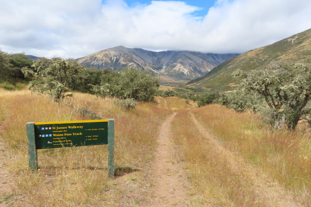
Apparently, I borrowed someone else’s legs for the day. Before I knew it, Boyle Flat, Rokeby and Anne Huts went whizzing by due to very easy trails on grassy river flats. I soon found myself on the Waiau Pass Route following the Waiau Uwha River towards Waiau Hut. While I kept my eyes peeled, I unfortunately didn’t spot any of the famous St James wild horses.

I decided to cross the Waiau Uwha River for a side trip up to Lake Guyon. It added extra mileage, but the beautiful alpine scenery made it well worth the effort.

After crossing back over the Waiau Uwha River, I pushed on toward Waiau Hut, needing my headlamp for the final 15 minutes.
I found the hut packed to capacity with tents scattered around the clearing, so I found some beech trees to camp under.
To top off a huge day, the hut’s water tank was bone dry, forcing me to drag my exhausted legs down to the river to fetch water for dinner. As I crawled into my sleeping bag, a curious local weka was already snooping around my vestibule so I quickly secured my shoes before it could pinch them.


Day 3: Crossing Waiau Pass, Lake Constance & Blue Lake
I woke up pumped to tackle Waiau Pass. The weather forecast wasn’t pristine, but it was the best window I was going to get before a major system rolled in over the coming days.
The track followed the Waiau Uwha River on the true right, crossing broad river flats and two old, bush-covered terminal moraines before reaching an informal campsite. From there, the real work began: an intense, sustained grind up to the pass.

I met plenty of southbound Te Araroa hikers along the way. They assured me that the Pass was still clear of cloud, so I powered up the steep climb, occasionally using my hands and knees to haul myself and my pack up boulders. The thru-hiker I met who were travelling south told me they found descending the pass particularly difficult and a lot of Te Araroa walkers consider it one of the most difficult sections of the Te Araroa Trail. From my experience, climbing the Waiau Valley side was considerably easier than descending it.
⚠️ Route warning: Be aware that this section is very steep (approximately 30–35-degree slope) and technical regardless of the direction travelled, even on a good weather day. There are many places where it is possible to slip or get stuck, particularly when there is snow and ice. Be prepared to turn back if the weather deteriorates or there is snow/ice which requires alpine gear.


Arriving At Waiau Pass
At the summit of Waiau Pass, I was rewarded with breathtaking views across to Lake Thompson and down to the striking basin with Rotopōhueroa / Lake Constance. Rotopōhueroa means “long calabash” in Te Reo Māori, referring to the shape of the lake. The calabash also has significance as a receptacle for a placenta and is part of Ngāti Apa identity.
As I sat taking in the panorama, the weather began to clag in right on cue. Rotopōhueroa vanished into the mist, visibility dropped to a few meters, and heavy rain started pelting down. I picked my way carefully down the steep, slick scree descent.
⚠️ Safety Note: If heading north, it is approximately 1.5 km from Waiau Pass to the valley floor, and you lose 530 m in altitude. Hard icy snow can remain until December in the first 150+ metres descent from the saddle, which can be very difficult to negotiate if the conditions are unfavourable.


Like magic, as soon as I dropped down to the shores of Rotopōhueroa / Lake Constance, the storm clouds parted into brilliant, hot sunshine.
Lake Constance / Rotopōhueroa
Even in mid-summer with lower water levels, Lake Constance is impressive. At 2km long and 700m wide, it sits in a post-glacial basin at 1,340 meters elevation and holds the title of New Zealand’s largest true alpine lake. It was formed by a large landslide from the nearby Franklin Ridge, damming the Sabine River. I spent an hour drying out in the sun next to it, admiring the deep blue water.
Top Tip: Rotopōhueroa / Lake Constance is sacred (tapu) to the local iwi, Ngāti Apa ki te Rā Tō. Do not swim, wash, take water or put any equipment into these lakes. These restrictions are in place to uphold its mauri (life force) and purity. Touching them also risks introducing the invasive alga lindavia that is present in Lakes Rotoiti and Rotoroa. It causes lake snow – a sticky mucus that hangs below the surface of the water.

The route then heads west away from the Lake up some steep guts into the cliffs around the lake before dropping down onto the moraine wall.
Top Tip: Do not try to take a short cut by following the lake edge – you will eventually get stopped by impassable bluffs and deep water and have to turn back.


The Clearest Lake in the World – Rotomairewhenua / Blue Lake
The descent down the moraine wall into the basin brought me to the iconic Rotomairewhenua / Blue Lake next to Blue Lake Hut.
Translated from Te Reo Māori as “lake of the peaceful waters,” it entirely lives up to its name. It is widely regarded as having the clearest natural freshwater in the world. NIWA measurements have recorded visibility exceeding 80 metres. The shifting turquoise and deep green hues change beautifully with the sunlight. Blue Lake is fed from Lake Constance and all the suspended particles are filtered from the water as it passes through the landslide debris that formed a dam between the two lakes. This explains the difference in colours between the 2 lakes.

Top Tip: Lake Rotomairewhenua / Blue Lake is sacred (tapu) to the local iwi, Ngāti Apa ki te Rā Tō. Do not swim, wash, take water or put any equipment into these lakes. These restrictions are in place to uphold its mauri (life force) and purity. Touching them also risks introducing the invasive alga lindavia that is present in Lakes Rotoiti and Rotoroa. It causes lake snow – a sticky mucus that hangs below the surface of the water.
Despite the hut and campsites around Blue Lake Hut being very busy, I still managed to find a good spot to pitch my tent.


Day 4: Blue Lake Hut to Upper Travers Hut via Travers Saddle
Leaving Blue Lake Hut in the morning, I tracked down toward West Sabine Hut. The thunderous roar of the Sabine River accompanied me for hours until it gradually faded into background white noise.

At West Sabine Hut, I stopped for a long chat with the hut warden, slightly delaying my climb over Travers Saddle. Keeping a close eye on the sky, I knew I needed to be prepared to turn back or pitch an emergency camp if the weather turned foul on the exposed tops.
⚠️ Route warning: The climb from West Sabine Hut up to Travers Saddle is steep – allow yourself plenty of time and it is best attempted with fresh legs at the start of the day.
As I climbed higher into the sub-alpine zone, cheeky kea were putting on an aerobatic display overhead. But right as I hit the bushline below Travers Saddle, the weather instantly changed. Heavy rain poured down, followed by a low, booming rumble.
For a second, I thought it was an avalanche echoing through the valley, but the flashing sky confirmed thunder and lightning over Waiau Pass. Assessing my position, I felt safe enough to push on toward the shelter of Upper Travers Hut, arriving soaking wet like a drowned rat. I waited out the worst of the deluge inside before slipping outside to pitch my tent under the shelter of the beech trees.

Day 5: Travers Saddle, Upper Travers Hut to Cupola Hut
The next morning, I grabbed my daypack and re-ascended Poukirikiri / Travers Saddle.
It was thick with fog on the way up, and I worried I was wasting energy on a second attempt for views. But just as I reached the saddle, the mist peeled back, revealing dramatic views down the Sabine Valley and across to Mt Windward on the Mahanga Range.


Descending back past Upper Travers Hut, I spent the afternoon cruising beneath the beautiful beech canopy before taking a detour up to Cupola Hut for the night. I spent the night enjoying chatting to Genn & Anna, a couple from Australia who had done many tramping and bike packing trips in New Zealand.

Day 6: Hopeless Hut and Coldwater Hut
From Cupola Hut, I made my way down the valley past John Tait Hut. Along the way, I took a short detour to check out Travers Falls before branching off to Hopeless Hut.


The side trip to Hopeless Hut turned out to be a real highlight. Tucked away off the main Te Araroa route, the trail was quiet, carpeted in lush green moss, and alive with native birds. Friendly toutouwai/South Island Robins and pīwakawaka/fantails darted down to inspect my shoes and walking pole, while kākā and kea called from overhead. It’s clear the recent pest trapping efforts in Nelson Lakes National Park are paying massive dividends for native bird numbers!

Heavy rain set in again by late afternoon, and I arrived at Coldwater Hut thoroughly drenched.

The Falling Tree
Positioned right on the edge of Lake Rotoiti, Coldwater Hut is an unbelievably scenic spot. With the hut all to myself, I spread my wet gear out to dry and started preparing dinner when I heard a massive crash. The whole hut shook and went dark.
I leaped away from the bench where I was cooking dinner, heart hammering in my chest. I stood there in the silence, confused and a little nervous. What just happened? Did aliens land on the roof? Was a pack of dinosaurs using the roof as a trampoline?
My imagination immediately ran wild. Then I looked out the window. It was completely blocked by a massive tree that definitely hadn’t been there a minute ago.
This massive tree had just fallen, narrowly missing me and the hut. A lazy tree that suddenly decided it had enough of standing vertical and desperately needed to lie down. A polite warning would’ve been nice! But no—it nearly squashed me instead.
Once the shock wore off, I stepped outside to inspect the damage. Luckily, the tree had only clipped the edge of the roof with its outer branches and the water tank was still accessible.


Day 7: Coldwater Hut to St Arnaud
I woke up to a roaring river and a brand-new challenge. My original plan to cross the Travers River and exit via Lakehead Hut was completely out—the river was in full flood.
Top Tip: There is a bridge to cross the Travers River much further up the valley. It’s ~5km before Coldwater Hut.
Time for Plan B: heading out along the western side of Lake Rotoiti past Whisky Falls.
Having run this trail previously, I knew there were several stream crossings that could easily become impassable after heavy rain. I mentally prepared myself to turn around or wait out flooded creeks if safety dictated it.
The first creek was swollen and swift, but relatively shallow. Drawing on my backcountry experience, I assessed the risk and waded across carefully.
Whisky Falls was thundering with extra volume from the storm.

I reached the road end ahead of schedule and walked the final 5km stretch into St Arnaud, stopping by the Department of Conservation (DOC) visitor centre to report the fallen tree at Coldwater Hut. I later heard from Glenn and Anna that DOC rangers had already cleared the trunk by the time they arrived two days later!
This trip will always be one of my favourite trips as it was a great combination of adventure, challenge and beautiful mountain scenery.

FAQ Section
Route
How hard is Waiau Pass?
Waiau Pass is not to be underestimated. It is a technical alpine pass. You need to be completely self-sufficient, have above-average fitness, and have good navigation, river crossing and survival skills. The route up to Waiau Pass is on an unformed, poled alpine route – on approximately 30-35°+ scree and steep boulders slope that requires very careful foot work and scrambling using hands and feet. It is not suitable for those with a fear of heights or exposure. Expect a 9 – 12 hour day and it is only appropriate to be attempted in good weather as there is absolutely no shelter on the Pass. Many people get delayed on this route due to weather so it is essential to carry extra supplies and allow for bad weather days. A good safety preparation video is this one from Mountain Safety Council: Waiau Pass; Travers-Sabine Circuit
Will there be snow?
Snow can still be present on the pass until early summer and sometimes even as late as January. If there is snow or ice on the route, you will need to turn back as alpine gear will be required.
Which is the best direction to walk the Waiau Pass Route?
The route can be walked in either direction. There are two passes that require consideration. DoC recommends climbing up to Travers Saddle from the Travers Valley as it is easier due to being a gentler climb. Approaching Waiau Pass from the Lewis Pass side has the advantage of completing the first days of the trip with a heavier pack on mostly flat terrain. It would involve climbing up the steep climb from Waiau Valley rather than descending it. My preference having completed both passes would be to head north from Lewis Pass and walk to St Arnaud. Even though this means a steep climb up to Travers Saddle from the Sabine Valley this is relatively easier than descending down from Waiau Pass into Waiau Valley.
Huts & Insects
How busy are the huts over summer?
The track up through Travers Valley and route over Waiau Pass to Lewis Pass are part of the Te Araroa Trail so get very busy over the summer months. Peak season will be December – February with walkers going both north and south along the route. Additionally, the Travers-Sabine Circuit including Blue Lake Hut is a very popular one over summer so the huts in the Travers & Sabine Valley get very busy. These huts are now all bookable as are the huts on the St James Walkway. Other huts like Waiau Hut are not bookable though. Carrying a tent is essential for shelter in case a hut cannot be reached due to a flooded stream, tiredness, or injury. It also gives you more flexibility on your trip, so you are not pinned down to hut bookings
Are water tanks reliable?
Yes, as the tanks collect rainwater. However, over summer with high user numbers, the tanks have potential to run dry. Carry a water filter to for river water if required to use if the water tank is dry. Waiau Hut had run out of water on my trip.
Are wasps & sandflies a problem?
Beech forests in Nelson Lakes National Park are notorious for heavy German wasp activity from January to April. Pack antihistamines and watch for wasp activity when walking. There is also an abundance of sandflies – take plenty of insect repellent
Logistics
How do I organise transport?
There is no bus that goes past either Lewis Pass or St Arnaud. Private shuttles must be arranged.
For the St Arnaud end: Nelson Lakes Shuttles, Trips & Transfers
For the Lewis Pass end: Hanmer Tours & Shuttle, Hanmer Springs TA Shuttle, Hanmer Springs Adventure Centre, Trips & Transfers
Where can I get last minute supplies?
St Arnaud has a general store and Boyle Village in Lewis Pass has a shop for basic supplies
Is there phone coverage?
No, don’t expect phone coverage until you get closer to St Arnaud on the last section of the Lake Rotoiti Track before reaching the Mount Robert Road. I didn’t have any reception on Waiau Pass. Sometimes it is possible to get patches of reception on high ridges in the backcountry but I didn’t find any of this on my trip.

More Tramping in Nelson Lakes National Park