
Tucked away in Arthur’s Pass National Park, the route through the Poulter Valley and over Binser Saddle with a side trip to Lake Minchin is a true classic for trampers seeking a bit of solitude, native wildlife, mixture of different backcountry huts and spectacular alpine scenery. Over four days, our journey took us past the cute Minchin Biv, along the crystal-clear edges of Lake Minchin, through beautiful beech forests and a visit to “Turnbull Hotel” aka Turnbull Biv.
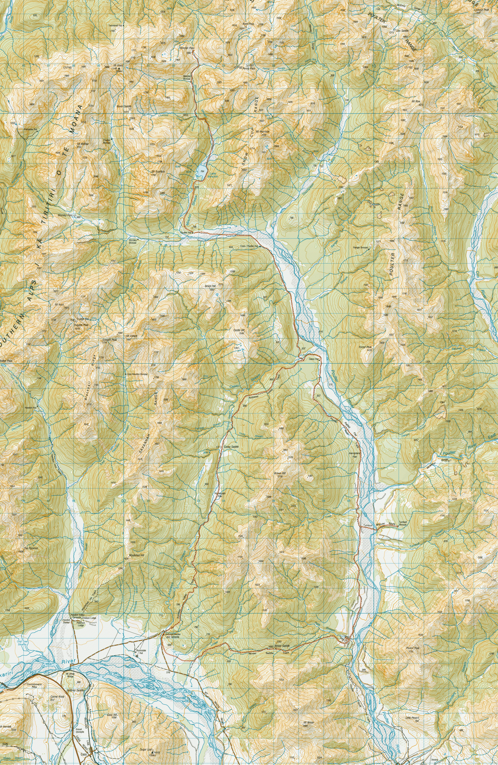
Planning Information
- Topo Map: BV21 Cass
- Parking: Plenty of parking at Andrews Shelter, 5km along Mt White Road, off SH73
- Parking Security: In summer, the campsite often has a number of campers present so vehicles are less isolated. However, the Arthur’s Pass area has been targeted by thieves in the past so leave no valuables in cars.
- Camping: Free camping at Andrews Shelter, no booking required
- Hut Fees: Poulter Hut & Trust/Poulter Hut are standard huts. Casey Hut is a serviced hut that must be booked all year around. Minchin, Worsley & Turnbull Bivvys are all free
- Seasonal warnings: Multiple river & stream crossings are required that could be impassable after heavy rain. In winter, the Minchin Pass route travels through avalanche terrain. January – March can have high wasp numbers. Wear light clothing & carry anti-histamines.
- Alternative route option: An alternative to Andrews Valley Track is to follow the Andrews streambed & Casey Stream gorge (in low flow).
Day 1: Andrews Shelter to Poulter Hut (via Andrews Valley & Casey Saddle Track)
- Distance: 24.3 km | Time: 6.25 hrs | Elevation Gain: 923 m
The Andrews Track started off with a bang with a quick, sharp climb before settling into a nice, easy walk up the valley through the typical South Island beech forest that I love. It was a warm day and the native birds were out in force.
We made quick time up the track to Casey Saddle. At the high point just past the saddle, we caught our first stunning views down into the Poulter Valley before descending towards the Casey Hut Junction.

The Poulter Valley Bush Bash
We thought we would be clever and cut off the corner of the track next to the Poulter River. False economies! We laughed at ourselves afterward because we got completely entangled in a bush bash trying to get around a bluff next to the river. After bashing our way back to the marked trail, it was easy walking along a 4-wheel drive track.
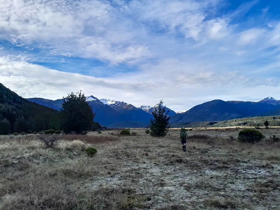
We passed a weather station—or “fire station,” as I mistakenly called it on a previous tramp after mishearing a friend’s comment—before finally coming to the junction for Trust/Poulter Hut (1.5hr). Rather than stopping here, we decided to keep the momentum going and power on to Poulter Hut, which was another 45 minutes further up the valley. The vehicle track faded out, and we continued on the true right of the Poulter for a few minutes before crossing and finding marker poles amongst the matagouri.
We could see the hut up-river, but it kept disappearing from sight intermittently. Even in the last 200 meters, it would vanish, leaving us wondering if it had ever actually been there. Eventually, the door appeared. We gratefully dropped our packs and enjoyed a warm hut that had been catching the sun all day long.
Hut Book Stories & Conservation Facts
Inside, we enjoyed reading a booklet about the history of the Arthur’s Pass huts and Lake Minchin, put together by the Mt White Station owners. Lake Minchin was named after E.C. Minchin. He began runholding here in 1857 and remained until 1870. In 1860 ownership of the run passed to Major Thomas Woolaston White, who built a new homestead near Lake Letitia on what became Mt White Station.
The hut’s intentions book also provided great reading. It contained everything from track warnings—like Peter, who had a “Type 2½ bordering on Type 3” fun day experiencing serious, unanticipated canyoning terrain in Trudge Stream—to notes on local birdlife like whio (blue duck), kiwi, kea, and the orange-fronted kākāriki.

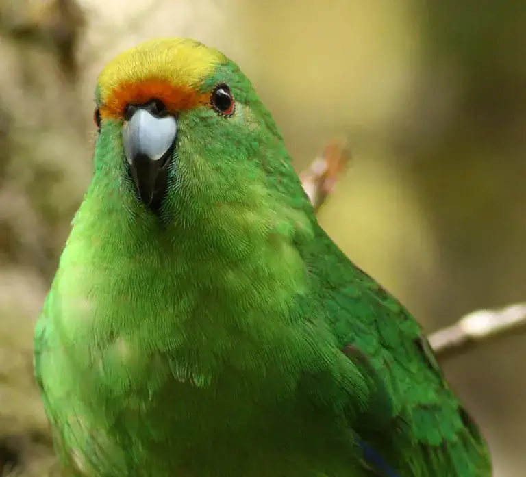
Species Spotlight: The Orange-Fronted Kākāriki (OFK)
It took us a while to catch on to what the Department of Conservation (DOC) meant in the hut book when they wrote about “OFK work”—Orange-fronted Kākāriki! These critically endangered parakeets are only found in two beech forests in Canterbury, and the Poulter Valley is one of them.
Twice thought to be extinct and subsequently rediscovered, they are a boom-and-bust species. They can breed for 18 months straight if food is plentiful, but decline rapidly if conditions change. They are especially vulnerable to rat and stoat predation; 85% of one valley population was lost to a single rat plague in 2001. It was fantastic to see predator traps stationed every 100 meters up the valley to give them a fighting chance.
Day 2: Side Trip to Lake Minchin & Minchin Pass
- Distance: 19.5 km | Time: 5.5 hrs | Elevation Gain: 898 m
The next day, we packed day packs and walked up the track behind the hut toward Lake Minchin (1hr). It was a nice, easy gradient through a beautiful beech forest. The reflections of the snowy peaks in Lake Minchin were stunning. We were incredibly lucky to get a good weather window; later in the day when we walked past again, the wind had picked up and the reflections had completely vanished.

We hoped to spot an orange-fronted kākāriki but didn’t get lucky this time. We crossed the crystal-clear Minchin Stream (prime whio territory) before climbing up to start toward Minchin Biv. The well-marked track climbs and then drops back down to safely avoid the gorge in Minchin Stream. The track rejoins Minchin Stream at its junction with Linwood Creek

Navigating Minchin Stream to Minchin Biv
We could see Minchin Biv just over 1km further up the valley with its bright orange roof and thought it wouldn’t take long to reach. How wrong we were.
Finding our way up Minchin Stream was slow going. We spent our time clambering over massive boulders to avoid deep pools, guided only by the occasional rock cairn or marker tape. I nearly slipped off a large boulder and took an accidental swim that I was desperate to avoid with the cooler spring temperature.
Eventually, we hit the poled route again and arrived at Minchin Biv, which is nestled beautifully on a river terrace with amazing views. After a late lunch, we decided to head toward Minchin Pass, knowing we might have to turn back if our progress was too slow.


The route, on the true right was poled, and though slightly overgrown, it was easy to follow. We reached Minchin Pass (1hr) just as a few raindrops made an appearance. Of course, it was that classic backcountry rain that stops the moment you put your jacket on!
Going back down Minchin Stream felt much quicker—not only because we now had the route sorted, but because we were mentally prepared for the slow pace. Back at the head of Lake Minchin, we heard a kea happily calling high above us. I called out, and it called back to me for a couple of minutes, much to Matt’s surprise. I love kea with their mischievous behaviour, like rolling rocks down hills onto trampers like on our Mt Owen trip or stealing boots at night in the Two Thumb Range. We timed our arrival back at Poulter Hut just as the rain returned.

Day 3: Poulter Hut to Worsley Biv & Turnbull Biv
- Distance: 25.67 km | Time: 6 hrs | Elevation Gain: 342 m
The next morning, we decided to venture further up the valley toward Worsley Biv. It features a charming, handmade little bridge outside the door to help visitors avoid the boggy ground. The biv was in excellent condition and looked like a lovely place to spend a night, with the sun streaming through the skylight.

After collecting our bags from Poulter Hut, we headed back down the valley. We stopped at Trust/Poulter Hut to sit in the sun, and then pushed on to the new Casey Hut for lunch just as a helicopter zoomed past.
From Casey Hut, we continued following the 4-wheel drive track as it alternated between the open valley and lush beech forest. The track through the open sections isn’t marked, but it is marked through the bush sections. The going is mostly through open tussock grassland with matagouri, mānuka and small-leaved coprosma scrub. During this section we finally bumped into our first people in three days—a couple of trampers and some bikepackers, all heading toward Casey Hut.

The Trick to Finding Turnbull Biv
Despite Turnbull Biv being marked as a route on the map, there was no marked junction on the trail. The Poulter River had changed course since publication of the map and is now braided. We had to back out of our initial crossing point because the flow was too fast and deeper than we expected so we walked further upstream until we found an easier place to cross.
Once on the other side, we located a cairn marking the turn up a dry streambed. It was full of windfall, and the track up to the river terrace had disappeared where the bank had given way with a slip.

Top Tip: Head up onto the river terrace exactly when the route marked on the map shows. It may not look very much like a track due to the bank having given way but trust the gps and find a route to climb the steep bank here. Continuing up the stream may seem the obvious option but it is really tree choked and much slower.

The “Turnbull Hotel”
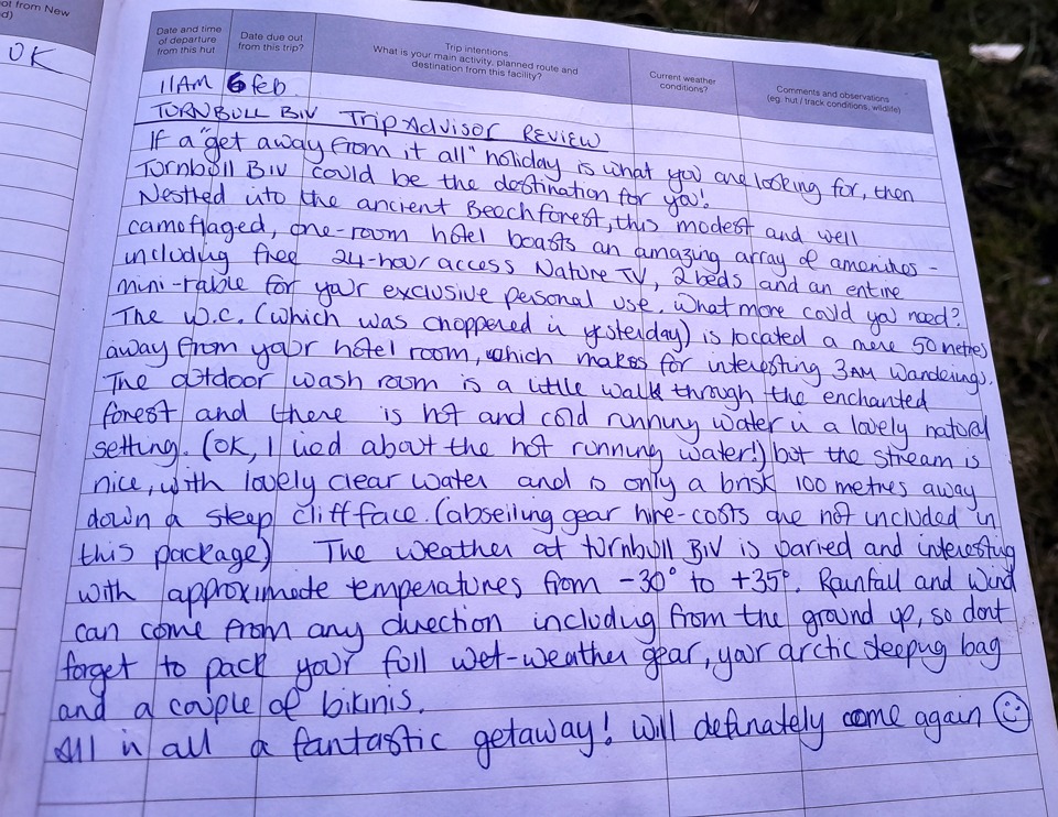
Turnbull Biv—or the “Turnbull Hotel,” as a delightful TripAdvisor-style review in the hut book called it—sits in a prime spot with views stretching both up and down the valley. It’s surrounded by a beautiful beech forest in which I decided to pitch my tent, while Matt claimed the biv. As per the TripAdvisor review, we both enjoyed the “24-hour nature tv” and were very glad to not to experience “rainfall coming from the ground up!”
According to that hut book review, the hut’s water supply was a stream south of the hut down a “steep cliff face with abseiling gear required” according to Turnbull Biv’s hut book. In reality, it was just a slightly slippery 5-minute walk, and we managed it just fine without the abseiling gear!
Day 4: Turnbull Biv to Andrews Shelter via Binser Saddle Track
- Distance: 17.4 km | Time: 4.25 hrs | Elevation Gain: 774 m
The next morning, we found a much easier way down to the stream following the poled route. There was just a small detour around a section of the eroded bank. The mountain bikers we met the day before went zooming past us. They were thoroughly enjoying having a fierce tailwind this time!
From the ford at Pete Stream, climb the terraces on the true right of that stream towards a marker on the terrace rim. It is easy to miss the turn-off to Binser Saddle, so be vigilant when nearing Pete Stream. Follow the outer lip of the highest terrace until a track winding through the low mānuka scrub becomes obvious. The initial climb up the Binser Saddle track was steep to get up onto the river terraces. Once inside the safety of the beech forest, it became a nice, gentle grind up to Binser Saddle. There are a few streams along the way to top up water if you are running low and expect some tree fall. There are some flat areas on the saddle to camp with water nearby.

The knee-thrashing descent from Binser Saddle
After the saddle, the track returns to the bush before it becomes dry, open and mossy. The local Canterbury wildlife really put on a show. A korimako (bellbird) spent a long time hanging out right in front of me, and a friendly pīwakawaka (fantail) visited us at lunchtime. After crossing a side stream, it travels through more storm-ravaged forest before a very steep descent down to the Waimakariri River flats, emerging just east of Lower Farm Stream.
We eventually made it down to Mt White Road for a short walk up the gravel road back to Andrews Shelter, where we were cheerfully applauded in by a camper staying at the shelter.
On the drive back to Christchurch, we made a scenic detour to Lake Sarah and drove past the unique rock formations of Og, Gog, and Magog. A neat coincidence since I had recently visited their twins down during a tramp on Rakiura / Stewart Island!
In this area, there’s lots of opportunities for other trips:
- Arthur’s Pass: Avalanche-Lyell-Bealey Loop
- Korowai/Torlesse Tussocklands Park there is the trip to Benmore-Annavale Loop & Sugarloaf Summit & Foggy Peak, Castle Hill Peak & The Gap.
- Craigieburn Range, there is Mt Izard, Mt Cloudsley & the Nervous Knob-Hamilton Peak Loop.