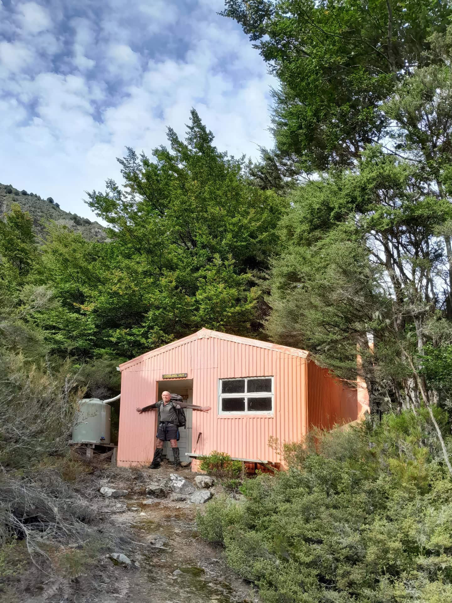
After Tony and I finished the Lees-Hellfire Circuit, we discovered that our good-weather window was going to continue for a few more days. Naturally, we decided to make the most of it with a trip into Gosling Hut.
We decided to have another attempt at climbing Bounds Peak, which we had tried to climb earlier in our trip into Hidden Hut and Turkey’s Nest via the Wye Route. This time, we would approach from Stronvar Station, walking up Gosling Stream to Gosling Hut and then climbing into the basin from there.

Fast Facts Planning Information
- Location: Glazebrook Conservation Area, Marlborough
- Topo50 Map: BR26 Mt Patriarch
- Duration: 3 days, 9.8km to Gosling Hut from Stronvar Station with 458m climbing
- Difficulty: Experienced due to off track navigation, river travel with multiple crossings of Gosling Stream required
- Start / Finish: Stronvar Station on Waihopai Valley Road (off SH 63 west of Renwick)
- Road Access: In good condition, last section of Waihopai Valley Road is unsealed but it is still suitable for 2WD.
- Hut: Gosling Hut (basic, 6 bunks), Booking through Marlborough Tramping Club, no hut fees but donations are very much appreciated to assist with hut maintenance
- Land Access: Access to Gosling Stream is across private land and permission must be gained before entering. Contact David Evans at Stronvar Station: 03 5724 809 or 021 439 964
- Dogs: With DOC permit only AND approval of private landowners
- Best Season: November – May
- Other Tramps in Raglan Range: Lees-Hellfire Circuit, Hidden Hut & Turkeys Nest via Wye Route, Leatham-Molesworth Circuit, Silverstream Biv-Bull Paddock-Lost Stream-Siberia Hut Traverse
Our Route Overview
| Section | Time (hours) | Elevation Gained (m) | Distance (km) |
| Stronvar Station → Gosling Hut | 3.5 – 4 | 458 | 9.8 |
| Gosling Hut →1,500m contour above Gosling Stream | 6 | 759 | 4.6 |
| Gosling Hut → Stronvar Station | 3 | 40 | 9.8 |

Walking up Gosling Stream to Gosling Hut
We started by walking through Stronvar Station on a 4WD road, passing the private hunting hut cleverly designed from a massive water tank before dropping down into Gosling Stream.
⚠️ Access warning for Gosling Hut: Access to Gosling Hut is across private land. Permission is required before entering Stronvar Station. Please contact the owners of Stronvar Station, David Evans, for permission and current access information: 03 5724 809 or 021 439 964

The valley is initially very wide, but it gradually narrows as you head further up the valley. Gosling Stream needs to be crossed multiple times, and the route involves plenty of boulder hopping, broken up by the occasional relatively flat terrace.
There have also been a number of slips into the stream, leaving plenty of debris behind. Be prepared for the stream travel to become increasingly rough as you make your way towards Gosling hut. By the end of it, you may even feel qualified for the Boulder Olympics, like our friend Emily!

There is an impressive waterfall and gorge in Gosling Stream just before the hut that needs to be bypassed. The route heads into the bush on the true right of the stream and is marked with orange ribbons and a rock cairn.


Eventually, Gosling Hut comes into view. It sits on a lovely terrace above the stream and can easily be seen from below. The route up to the hut is marked with permolat and painted rocks, and there is a rope to assist with the steep climb onto the river terrace.

Gosling Hut
Gosling Hut is a cute little salmon pink coloured hut, and while we were there, we gave it a bit of love with a clean.
The hut also has a rather remarkable history.
In 1956, members of the Marlborough Tramping Club decided that a hut in the Gosling Valley would be useful for tramping and climbing trips into the Bounds Range. The timber for the hut was all pre-cut by a club member in his woolshed over winter.
Everything had to be carried into the valley on the backs of club members. This even included the chimney, which was carried in on two manuka poles!
That is some impressive dedication to building a hut in a remote valley.
Gosling Hut had its grand opening in October 1957, and the total cost of construction was just $157.59.

A relaxing afternoon at Gosling Hut
After the walk in, we spent a lovely relaxing afternoon at the hut.
It was a hot day, so we both enjoyed going for swims in Gosling Stream. After the boulder hopping and rough stream travel, cooling off in the stream was pretty much perfect.
Sometimes the best part of a tramp is simply having nowhere else you need to be.
Another attempt at Bounds Peak
The next day we left Gosling Hut determined to finally summit Bounds Peak, after so many previous attempts.
Our most recent attempt had been from the Wye Route and Turkey’s Nest, complete with exploding mushrooms. This time we were hoping that approaching from Gosling Hut would finally be the winning strategy.
I had brought some dinosaur lollies with me, which provided essential climbing fuel as we headed upwards.

It was a very hot day, and before long we realised that we were still feeling the fatigue from the Lees-Hellfire Circuit we had just completed and made a mistake in climbing out of Gosling Stream too early reaching a deep, uncrossable gully. We simply didn’t have the motivation to back track and finish the climb towards Bounds Peak. I think there may also have been an element of learned helplessness involved after our previous failures to climb the elusive Bounds.
⚠️ Good to know: The route to Bounds Peak from Climb NZ – The stream forks about 1.2km upstream from the hut. The true right branch soon becomes rugged; bushbash past a waterfall on true right, following a cairned trail, into upper basins and on to the summit. The true left branch is easily followed through open forest and across large tussock and scree basins to the summit ridge.

The Elusive Bounds
Tony had attempted Bounds nine times, with 39 different people including our friend Emily, while I had failed once with him. Most of these attempts had failed due to weather conditions (one attempt is A Restorative Retreat Weekend). The whole situation was rather hilarious when you consider that Tony climbed Aoraki/Mount Cook on his first attempt, yet this 2,000-metre peak in the Raglan Range appeared to be completely unclimbable!
Perhaps Bounds Peak simply has it in for us.


The Busy Bumble Bees
We descended back towards Gosling Hut, keeping ourselves distracted during the bash bash with a game of alliteration based around the letter B.
This seemed particularly appropriate given the boulder hopping, Bounds Peak and, unfortunately, the bumble bees.
There was a swarm of them chasing us – or, more accurately, mostly chasing me. I had a blue pack, which seemed to be attracting every bumble bee in the valley.
At least we had plenty of B words to keep us entertained on the way down.


Will we ever climb Bounds?
Tony and I will be back to climb Bounds Peak.
Preferably before our friend Emily, who has also now had two attempts at climbing Bounds.
The race is on!
For now, though, Gosling Hut was another great little adventure in the Marlborough mountains. The combination of walking up a remote valley, boulder bashing Olympics of Gosling Stream, a historic backcountry hut and the challenge of Bounds Peak made it a memorable trip – even if we didn’t actually make it to the summit. It was another peak to add to my list of ‘The Mountains I have not climbed’ which includes Mt Tarahaka, Mt Princess, Mt Potts, Mt Morris, Scotts Knob…….
And perhaps that’s the thing about tramping: sometimes the failed attempts make the best stories.