
Some faults in
the Tararuas
The Tararua Range is famous for its ‘faults’—usually the relentless rain or the 80-day-a-year sunshine quota. But look deeper at the topography, and you’ll find the real faults: the tectonic scars that have literally torn the landscape apart. The Wellington Fault, a geological giant, snakes its way from the South Coast, under Parliament, and right through the heart of the range at Totara Flats. Over the last million years, it has acted like a giant conveyor belt, breaking ancient river systems in half and dragging the western mountains 7km north relative to those in the east. From the ghost forests buried beneath 3 metres of gravel to the ‘kinked’ path of the Waiohine River, the Tararua isn’t just a place to hike—they are a living, breathing map of New Zealand’s seismic past and its future.
We often talk about the Wellington Fault under our feet in the city, but some of the most dramatic evidence is hidden deep in the Tararua Range. From burying entire forests at Totara Flats to breaking river systems in half, the fault has reshaped the landscape by a staggering 7 kilometres over a period of about 1 million years. Here is how to spot the “faults” in the Tararuas on your next tramp.
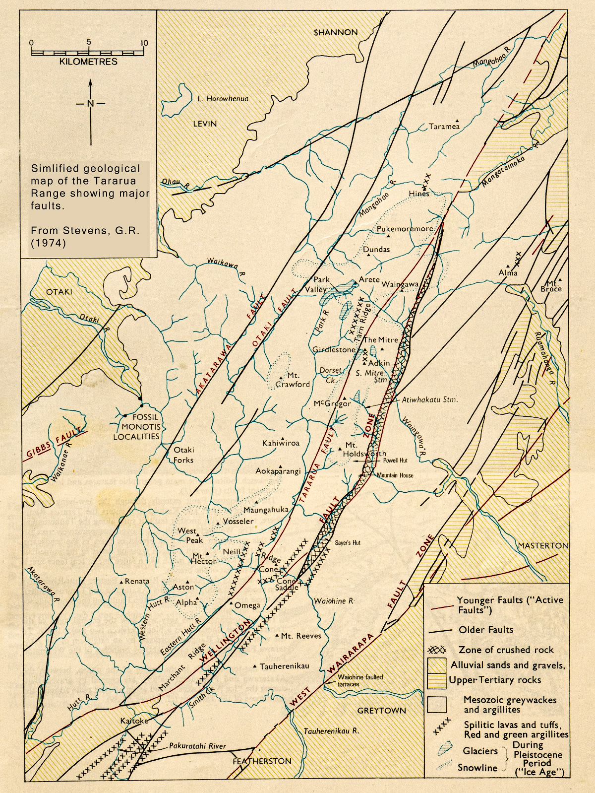
One of the most active faults is the Wellington Fault which comes ashore on Wellington’s south coast, carries on up Long Gully and through Karori, under Parliament Buildings and the ferry terminal, along the western side of the Hutt Valley, past Kaitoke—where it takes a 2 km side-step to the east—up the Tauherenikau Valley, over Cone Saddle, and then right on through Totara Flats—although the fault scarp is not visible through the flats themselves but is about 500 m to the west among the trees. The fault then continues across Pig Flat, along the Atiwhakatu and Waingawa Valleys, across Cow Saddle before finally leaving the Tararuas at Putara and becoming the Mohaka Fault after it crosses the Manawatu River.

Perhaps you have noticed that most of the main rivers on the Wairarapa side of the Tararua Range start by running towards the east, then suddenly turn south for about 7 km, before turning eastwards again as before. Well, if you get a Tararua map and cut along the line of the Wellington Fault and then move the western piece a map distance of about 7 km south you will find many of the rivers join up again and run eastwards without the southward kink.
The Ruamahanga, Waingawa, Waiohine, and the Tauherenikau are ‘straightened out’ while a lot of the smaller streams join up in interesting ways. For example, South Mitre Stream becomes the headwaters of the Atiwhakatu, while the Atiwhakatu is the headwaters of Carrington Creek.
The reason for the odd kinks is because during the life of the Wellington Fault since the Tararua Range drainage patterns were established, the western side has moved about 7 km north relative to the eastern side over a period of between 0.8 and 1.3 million years—and the rivers have been forced to flow that distance south along the line of the faults before being able to once again flow eastwards out towards the coast.
Geological evidence points to the Wellington Fault being divided into three separately active segments—from Wellington to Kaitoke, Kaitoke to Putara, and Putara northwards. Each of these segments have ruptured either separately, or possibly sometimes together, many times in the past.
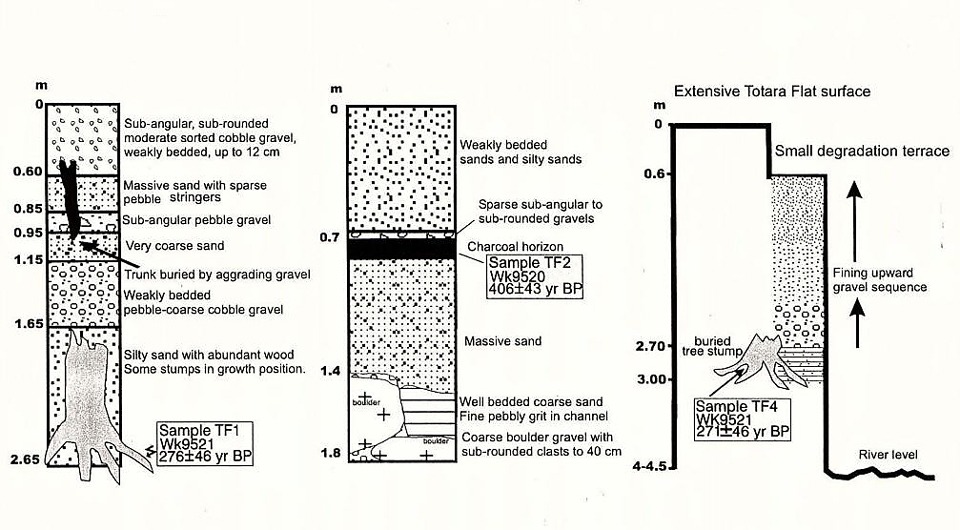
One rupture on the Wellington segment approximately 500 years ago caused significant landslides in the Tararuas and the resulting debris buried an existing forest at Totara Flats to a depth of 3 m. Boreholes made recently at the flats showed the trunks of large forest trees still in their growth position but under the 3 m of gravel. The existing Totara Flats may well suffer the same fate sometime.
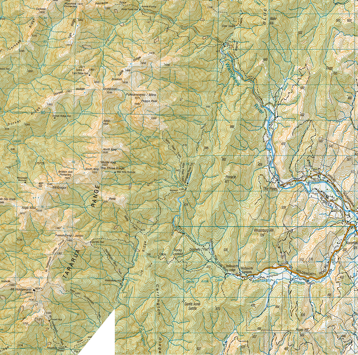
The Wellington Fault shows itself in other areas too. When climbing from the Mountain House Shelter to Powell Hut you climb up the scarp of the fault. Similarly, when climbing from Mitre Flats Hut (which is sited directly on the Wellington Fault) to Peggy’s Peak.
Other significant faults in the Tararuas are: the Tararua Fault which is a branch of the Wellington Fault and runs along the Eastern Hutt River, across Hell’s Gate, between Holdsworth and Isabell, and northwards to re-join the Wellington Fault at Mangatainoka; the Otaki Fault that follows the upper Otaki River; and the Akatarawa Fault that passes northward through Otaki Forks and on to Shannon.
Additionally, defining the eastern side of the Tararua is the West Wairarapa Fault that last ruptured in 1855 with an estimated 8.2 to 8.3 magnitude earthquake causing uplift of about 2.7 m at the fault and 1 m in Wellington with considerable damage to the buildings of the early settlement.
Geological evidence along the Wellington Fault shows that, based on elapsed time since the last event compared with the average recurrence interval, the Wellington to Kaitoke segment of the fault is not yet overdue to rupture (but is in the ‘window’) which is perhaps good news for Wellington City, but that the Putara northwards section has not ruptured for at least 1100 years and that the prior interval was only about one third to one half of the present elapsed time so it is likely that it is this segment of the Wellington Fault that will rupture first in the future—with a possible magnitude 7.4-7.8 earthquake.
For more photos of the Tararua Range visit www.tararuaphotos.com.