Centrally located in North Island, Tongariro National Park serves as an adventure hub for those seeking a landscape shaped by fire, ice, and ancient legend. As New Zealand’s first National Park and a UNESCO Dual World Heritage area, it offers a rare convergence of geological wonder and deep Māori spiritual heritage.
A Land of Giants
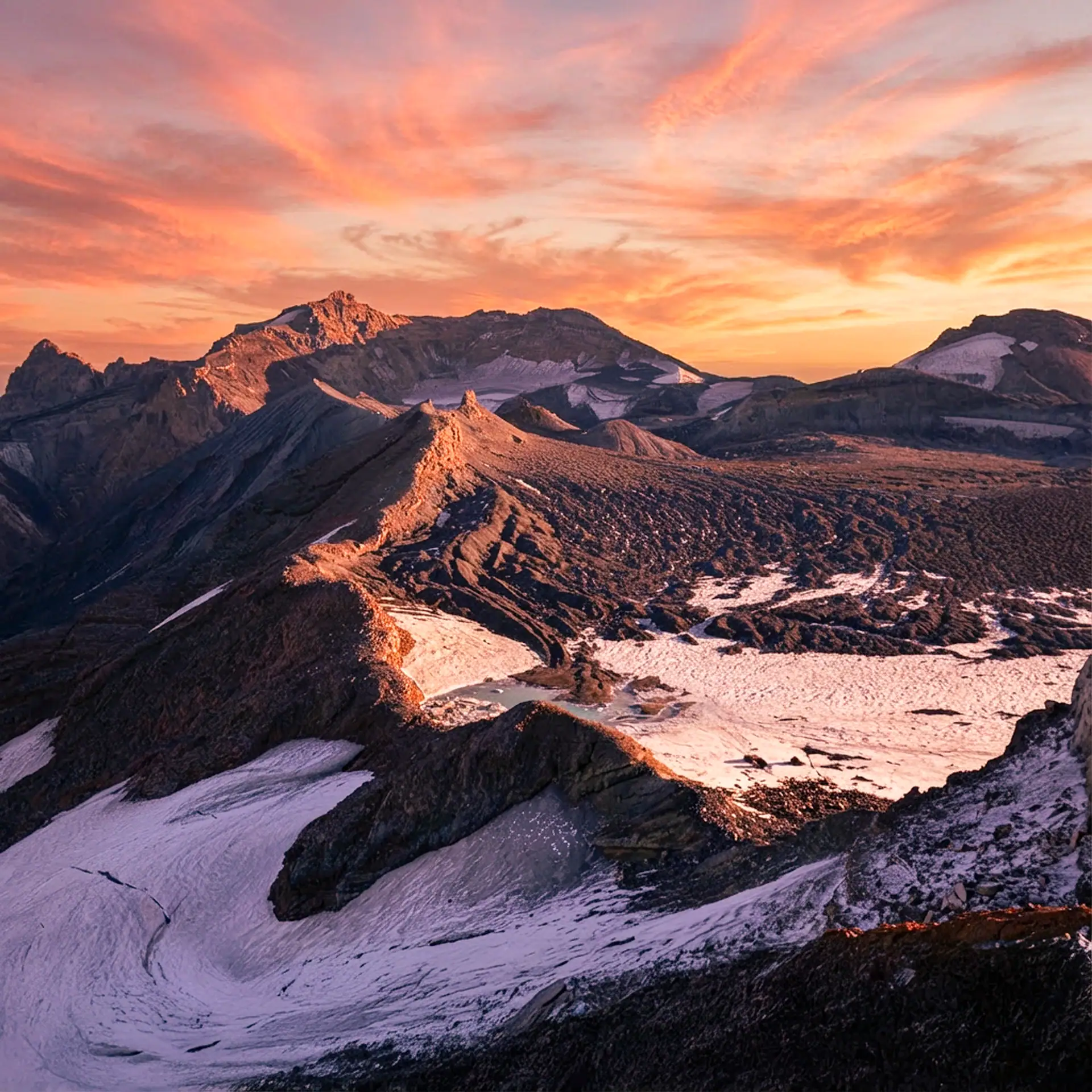
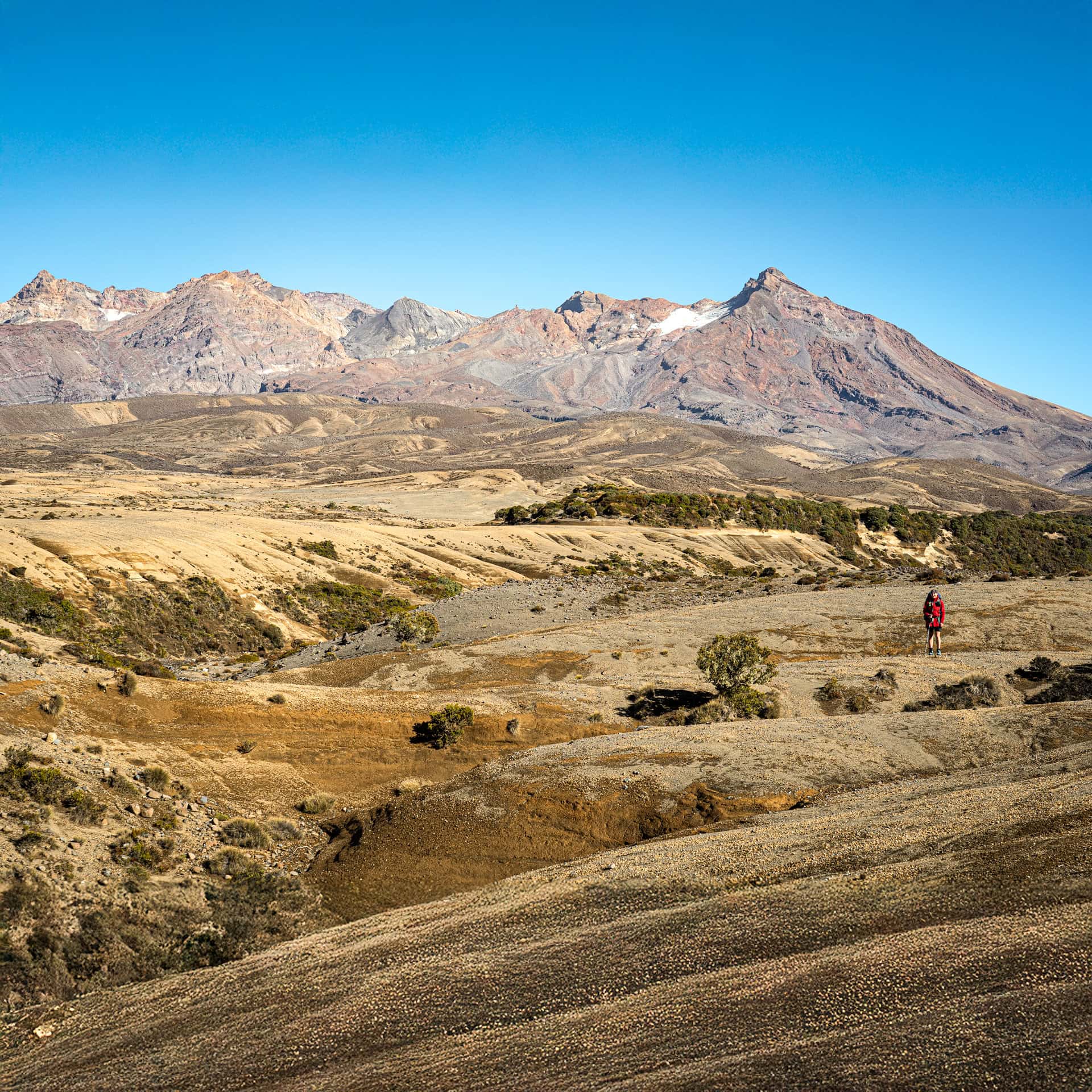
The park is dominated by the Tongariro Volcanic Centre, featuring three active volcanoes. Mount Ruapehu stands as the North Island’s highest point (2,797 m), home to North Islands only permanent glaciers, and the region’s premier ski fields. Beside it sits the iconic, conical vent of Mount Ngāuruhoe, and the sprawling, multi-cratered massif of Mount Tongariro. The topography ranges from lush rainforests on the lower western slopes to the sandy, windswept Rangipo Desert in the east.

Alpine Extremes
Visitors should prepare for a “four seasons in one day” climate. The weather here is famously fickle; alpine gales and sudden mists can descend at any time of the year.
- Winter: Snow covers the higher peaks, transforming the park into a world-class destination for skiers and mountaineers.
- Summer: Long daylight hours are perfect for easy hiking to multi-day expeditions, though rapid changes in the weather require hiking experience and adequate clothing.

Nature’s Masterpieces
Whether you are here for a gentle stroll or a gruelling summit, the park’s scenic attractions are unparalleled:
- The Tongariro Alpine Crossing: A world-renowned 20 km hike through volcanic craters and past the brilliant, mineral-tinted Emerald Lakes.
- Glacial landscapes: Nine permanent glaciers – one with remarkable ice caves.
- Volcanic Wonders: Explore the steaming vents of Red Crater or the golden, mineral-crusted Silica Rapids.
- Waterfalls and Film Sites: Visit Taranaki Falls or seek out the filming locations for “Mt. Doom” and “Gollum’s Pool” from The Lord of the Rings.
- Hauhungatahi Remote Experience Zone – off-track hiking to the oldest volcanic peak in the park
The Restorative Rāhui (2026 Update)
As of early 2026, many visitors to Tongariro National Park will witness a landscape in transition. Following the significant wildfires of late 2025, a 10-year restorative rāhui (Rāhui Whakaora) has been placed over the affected 3,000 hectares by Ngāti Hikairo ki Tongariro. While the Tongariro Alpine Crossing remains open, the first section through the Mangatepōpō Valley reveals a blackened, sobering landscape. This rāhui is a commitment to the ‘mauri’ (life force) of the mountain—all hikers are asked to stay strictly on the marked tracks to allow native tussock and sub-alpine herbs to regenerate without disturbance.

Sacred Summits
The concept of Sacred Summits in Aotearoa New Zealand is rooted in the deep spiritual connection Māori hold for the land. For many iwi (tribes), mountains are not merely geographical landmarks but tūpuna (ancestors) and atua (deity-like entities). They are tapu—sacred and restricted—representing the physical link between the earth and the heavens.
When traversing the volcanic Mt Ruapehu, Mt Ngauruhoe, and Mt Tongariro, the highest peaks in Tongariro National Park, climbers are increasingly encouraged to practice kaitiakitanga (guardianship) by stopping short of the literal highest point. To stand directly upon the pūmotomoto (the crown of the head) of a mountain like Ruapehu is often seen as a transgression against its mana (prestige/authority) and mauri (life force). For the people of Ngāti Tūwharetoa and Ngāti Rangi, these peaks are the heart of their identity.
By observing this boundary, manuhiri (visitors) show whakaute (respect) for the kōrero tuku iho (oral traditions) that define these landscapes. Rather than “conquering” a peak, the act of pausing below the summit acknowledges that we are merely guests in a realm belonging to the atua. This gesture honors the wairua (spirit) of the peaks, ensuring that the sanctity of the te kahui maunga (the assembly of mountains) remains intact for future generations.

10 Frequently Asked Questions: Tongariro National Park
1. Is the Tongariro Alpine Crossing currently open following the late 2025 wildfires?
Yes, the Tongariro Alpine Crossing remains open to hikers. However, a 10-year restorative rāhui (Rāhui Whakaora) is active across 3,000 hectares of the park, including parts of the Mangatepōpō Valley. Visitors will see visible fire damage along the initial sections of the track and must stay strictly on the designated paths to protect regenerating sub-alpine plants.
2. Why are hikers asked not to climb to the absolute summit of Mount Ruapehu or Mount Ngāuruhoe?
The volcanic peaks are deeply sacred (tapu) ancestors to local Māori iwi. Standing on the literal highest point, or the “crown of the head” (pūmotomoto), is considered a transgression against the mountain’s mana (prestige) and mauri (life force). Out of respect for these traditions, climbers are strongly encouraged to practice kaitiakitanga (guardianship) by pausing their climb just short of the true summits.
3. How long does it take to hike the Tongariro Alpine Crossing?
The 20-kilometre point-to-point hike typically takes between 7 to 9 hours to complete. Because it is a demanding trek with steep elevation gains—such as the climb up to Red Crater—it requires a moderate to high level of fitness, proper hiking footwear, and early morning departure planning.
4. Where were Lord of the Rings scenes filmed in Tongariro National Park?
The park provided the dramatic backdrop for Mordor, Mount Doom, and Ithilien. The perfectly conical Mount Ngāuruhoe served as the digital base for Mount Doom. Nearby, the rocky terrain of the Whakapapa Skifield was used to film the opening battle of The Fellowship of the Ring, while Tawhai Falls is widely known to fans as “Gollum’s Pool”. Check out the Tongariro locations including GPS coordinates.
5. What should I pack for a summer hike in Tongariro National Park?
You must prepare for sudden, extreme weather shifts, often described as “four seasons in one day.” Even in mid-summer, essential gear includes wind- and waterproof layers, a warm fleece or thermal base layer, sturdy hiking boots, a sun hat, sunscreen, plenty of water (at least 2–3 litres), and plenty of food. Sudden alpine mists and gales can drop temperatures rapidly.
6. Can you visit the permanent glaciers and ice caves on Mount Ruapehu?
Mount Ruapehu holds the North Island’s only permanent glaciers, located around the Summit Plateau. While remarkable ice caves form within these glacial landscapes, accessing them requires advanced mountaineering experience, specialized winter gear, or booking a guided tour with an alpine expert. The terrain is highly hazardous for unguided, casual hikers.
7. Do I need a permit or booking to walk the Tongariro Alpine Crossing?
No, unless you are using a commercial shuttle for transport. There is a free track booking system in place to manage visitor numbers and environmental impact. All visitors are encouraged to make a booking through the Department of Conservation (DOC) booking system before starting the hike, but it is not compulsory unless you will be using a shuttle. Shuttle operators are required to sight booking confirmations before they can accept passengers.
8. What is the Rangipo Desert, and where is it located?
The Rangipo Desert is a barren, windswept volcanic plateau located on the eastern side of Mount Ruapehu. Despite receiving high rainfall, its porous, sandy volcanic soil and harsh alpine winds prevent most vegetation from growing. State Highway 1—famously known as the Desert Road—cuts right through this landscape, offering stark, dramatic views of the mountains.
9. What are the best short walks in Tongariro National Park?
If you aren’t up for a grueling 20 km trek, the park offers excellent short walks, including:
- Taranaki Falls Track: A highly popular 2-hour loop leading to a stunning 20-metre waterfall tumbling over ancient lava flows.
- Silica Rapids Walking Track: A 2.5-hour walk showcasing golden, mineral-crusted cascading streams.
- Tawhai Falls: An easy, 20-minute return walk through native bush to a beautiful rock-shelf waterfall.
10. Can you ski in Tongariro National Park during the winter?
Yes, Mount Ruapehu hosts the North Island’s premier commercial ski fields. Whakapapa and Tūroa ski resorts occupy the slopes of the active volcano, offering world-class terrain for skiers and snowboarders from roughly July to October, depending on seasonal snowfall.